The main purpose of this ongoing blog will be to track planetary extreme, or record temperatures related to climate change. Any reports I see of ETs will be listed below the main topic of the day. I’ll refer to extreme or record temperatures as ETs (not extraterrestrials).😜
Here is a new feature for this blog, which I will add daily. This is the latest inciteful Green News Report from my friends Desi Doyen and Brad Friedman at Progressive Voices. Hit ‘continue reading,’ listen, then hit return to see my daily topics:

Green News Report with Brad Friedman & Desi Doyen
Episode: 9/24/2026 — More info…
Dear Diary. It’s been a while since we have had a check on global sea ice, so let’s do exactly that. During 2026 thankfully we have seen no record low sea ice extent, but areal coverage is quite concerning. Of course, sea ice acts as a good reflector of incoming solar radiation. Without it we have on our hands a tipped tipping point in which the planet continues to warm despite any best efforts to stem carbon pollution.
Yesterday I noticed a good 2026 sea ice summary written on Carbon Brief, which we will use for today’s main subject. Here is that article:
‘Concerning’ low sea ice persists as Antarctic hits third-lowest winter peak – Carbon Brief
‘Concerning’ low sea ice persists as Antarctic hits third-lowest winter peak
25.09.26
By: Ayesha Tandon
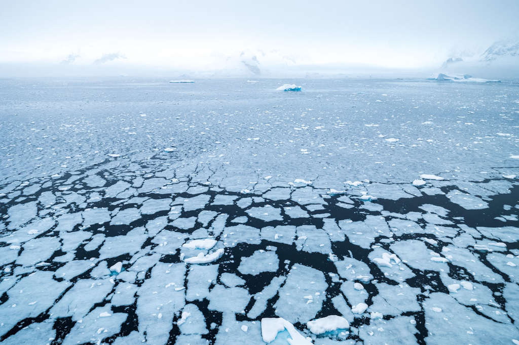
Antarctic sea ice breaking up. Credit: Mara Unkefer / Alamy Stock Photo
Antarctic sea ice has recorded its third-smallest winter peak extent since satellite records began 48 years ago, new data reveals.
Provisional data from the US National Snow and Ice Data Center (NSIDC) shows that Antarctic sea ice hit its annual winter peak on 14 September, with an extent of 17.59m square kilometres (km2).
The organisation notes that the data is still preliminary, adding that “large fluctuations in extent are typical of Antarctic sea ice near the seasonal maximum”.
One expert tells Carbon Brief that it is “concerning to see these low values persisting”, but says that scientists need more time to determine whether this represents a “structural shift” in Antarctic sea ice extent.
Meanwhile, at the Earth’s other pole, Arctic sea ice reached its annual minimum on 12 September, ranking as the joint-10th lowest in the satellite record.
The NSIDC notes that the last 20 years have seen the lowest 20 Arctic sea ice extents in the satellite record.
Antarctic peak
Dr Lettie Roach, a polar climate scientist at the Alfred Wegener Institute in Germany, tells Carbon Brief that this year’s Antarctic sea ice maximum was “well below average for the season”. She warns that, “after several decades of stable or increasing winter Antarctic sea ice conditions, it is concerning to see these low values persisting”.
She adds:
“Compared with the Arctic, it’s less clear how recent changes in Antarctic sea ice are attributable to human-caused warming vs natural variability. We need more years of observations to better understand whether this is truly a structural shift.”
Dr Clare Eayrs, a postdoctoral researcher at the Korea Polar Research Institute (KOPRI), tells Carbon Brief that, since recording a “near-average February minimum” extent, Antarctic sea ice has “returned to unusually low winter coverage”.
She notes that Antarctic sea ice extent in July and August this year were the fifth and fourth lowest on record, respectively, adding that “all five of the lowest July extents have occurred since 2022 and all four of the lowest August extents since 2023”.
The chart below shows Antarctic sea ice extent in 2025 (dark blue) and 2026 (red) so far. For comparison, the chart shows decadal averages (dotted lines) as well as 2023 (mid blue), the year of the smallest winter sea-ice maximum on record.
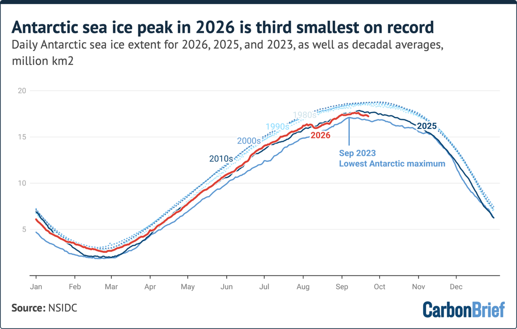
Daily Arctic sea ice extent for 2026 and 2025, with decadal averages for comparison, based on data from the NSIDC. Chart by Carbon Brief.
Eayrs tells Carbon Brief that the regional pattern of Antarctic sea ice cover “changed substantially during the growth season”.
For example, she says that “in April, the Bellingshausen Sea remained almost entirely ice-free, while the neighbouring Amundsen Sea had more ice than usual”.
However, by late August, changes in atmospheric pressure and wind meant that “the Bellingshausen deficit had largely recovered, while ice was unusually scarce in the Amundsen Sea and across much of East Antarctica”.
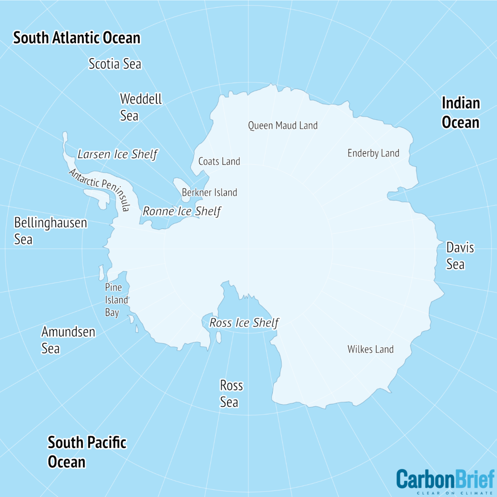
Map showing the main regions of the Antarctic. Credit: Carbon Brief
Arctic minimum
Meanwhile, the Arctic recorded its minimum summer sea ice extent on 12 September. At 4.60m km2, this year ties with 2025, 2010 and 2008 as the 10th-lowest sea ice extent on record.
The chart below shows Arctic sea ice extent in 2025 (dark blue) and 2026 (red) so far. For comparison, the chart shows decadal averages (dotted lines) as well as 2012 (mid blue), the year of the smallest summer sea-ice minimum on record.
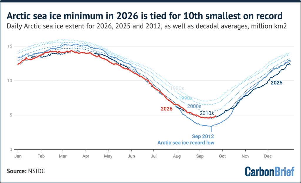
Daily Antarctic sea ice extent for 2026 and 2025, with decadal averages for comparison, based on data from the NSIDC. Chart by Carbon Brief.
Roach tells Carbon Brief that although this minimum is not “record setting”, it is still “lower than any sea ice minimum before 2007”. She adds:
“Human-caused climate change has reduced Arctic sea ice cover and thickness, so the region is fundamentally different compared to a few decades ago.”
Scientists have been tracking Arctic sea ice thickness using a reanalysis produced called the Pan-Arctic Ice Ocean Modeling and Assimilation System (PIOMAS) since 1979.
In March 2026, the National Oceanographic and Atmospheric Administration (NOAA) terminated a global dataset of air pressure that scientists relied upon to produce PIOMAS, forcing both datasets to stop publishing updates.
The PIOMAS website says it will take “considerable effort and time” to find alternative data to use in their reanalysis. It adds that “we don’t yet have a good sense if that’s possible with available funds and if so, when we will be able to resume production of a new PIOMAS timeseries”.
Roach also notes that August saw record-breaking heat sweep across much of the world, explaining that high temperatures “extended into Arctic coastal regions, close to regions with substantial sea ice loss – particularly the Barents-Kara and East Siberian seas”.
Dr Zack Labe, a scientist at Climate Central, tells Carbon Brief that the absence of a new record does not mean that ice cover is becoming more “resilient”. He says:
“Local weather patterns across the Arctic play a really important role in year-to-year sea-ice extent, even as the long-term trend is clearly downward.”
Labe tells Carbon Brief that weather in the Arctic this summer was “influenced mainly by lower pressure toward the central Arctic, which brought cloudier and cooler conditions that limited surface melt and delayed the start of the melt season”.
He explains that this “was most obvious across parts of the Beaufort and Chukchi seas, where the melt season didn’t really kick off until after early July, which was more than two weeks later than normal”.
In contrast, he says, the Atlantic side of the Arctic “had a much more extreme summer”, with sea ice in the Barents Sea recording its “earliest melt-out on record”.
This was partly due to “unusually warm air and ocean temperatures”, Labe says. He notes, for example, that parts of western Siberia saw unusually persistent temperatures more than 5C above the 1981-2010 average for much of the summer, which extended out over the Kara Sea and contributed to substantial ice melt in this area”.
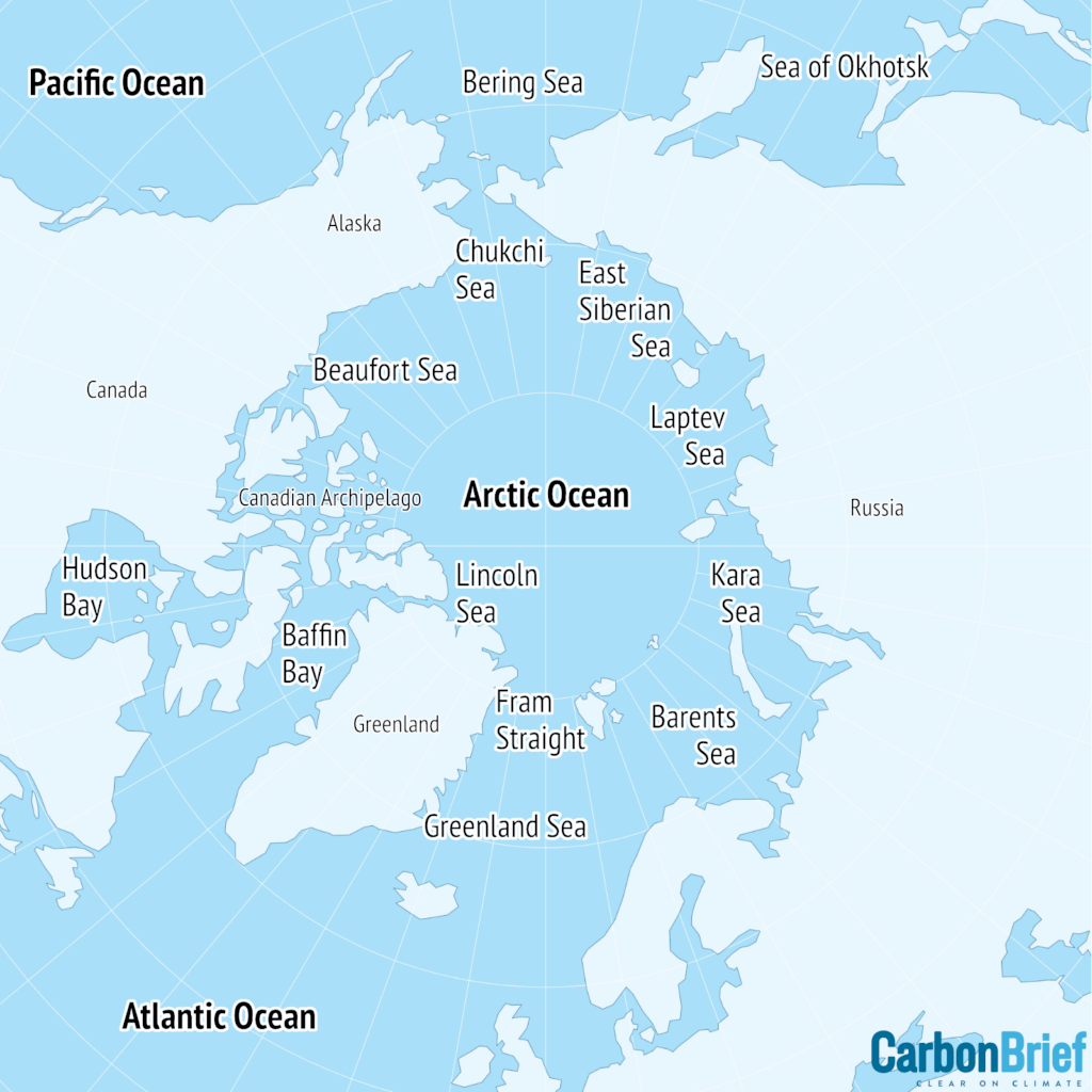
Map showing main regions of the Arctic. Credit: Carbon Brief
Labe tells Carbon Brief that, going forward, scientists need “more data and observations of other sea-ice metrics, like ice thickness, which may give us better insight into the overall condition of the ice pack, especially during years like 2026 when it is very fragmented”.
(In March 2026, Arctic sea ice reached its peak extent for this winter, clocking in as the joint-smallest in a satellite record going back almost half a century.)
Here are some “ETs” recorded from around the U.S. the last couple of days, their consequences, and some extreme temperature outlooks, as well as any extreme precipitation reports:
Here is More Climate News from Saturday:
(As usual, this will be a fluid post in which more information gets added during the day as it crosses my radar, crediting all who have put it on-line. Items will be archived on this site for posterity. In most instances click on the pictures of each tweet to see each article. The most noteworthy items will be listed first.)
https://bsky.app/profile/climateconnections.bsky.social/post/3mwem3hvqog2z