Made November 2022/Updated NOV 2023/JUL 2025/AUG 2026
This archive is intended to serve as a quick-reference record of French monthly and annual national temperature averages, anomalies, and associated daily record counts, while also providing a research framework for examining how record ratios respond to changing temperature anomalies. By preserving these values together in one place, the goal is not only to document how France’s climate has evolved, but also to develop and test a statistical relationship that may eventually allow forecast temperature anomalies to be translated into expected warm-to-cold record ratios.
Another purpose of this post is to catalogue counts of daily records (high maximums, high minimums, low minimums, low maximums) coming into the National Center for Environmental Information’s site and all related charts and graphs produced in my Excel files for those data sets coming into their system from France. I am in the process of constantly updating this data verifying the 2009 Meehl et. all surface Records published in Geophysical Science that I initiated from 2000-2009. Each individual count could be a tied surface record or one broken by several degrees Fahrenheit. Here is the link to the NCEI site:
Here is the link to the NCEI site:
https://www.ncdc.noaa.gov/cdo-web/datatools/records
More from NCEI:
“The monthly records summarized here are compiled from a subset of stations in the Global Historical Climatological Network. A station is defined as the complete daily weather records at a particular location, having a unique identifier in the GHCN-Daily dataset.
For a station to be considered for any parameter, it must have a minimum of 30 years of data with more than 182 days complete each year. This is effectively a “30-year record of service” requirement but allows for inclusion of some stations which routinely shut down during certain seasons. Small station moves, such as a move from one property to an adjacent property, may occur within a station history. However, larger moves, such as a station moving from downtown to the city airport, generally result in the commissioning of a new station identifier. This tool treats each of these histories as a different station. In this way, it does not “thread” the separate histories into one record for a city.
This tool provides simplistic counts of records to provide insight into recent climate behavior but is not a definitive way to identify trends in the number of records set over time. This is particularly true outside the United States, where the number of records may be strongly influenced by station density from country to country and from year to year. These data are raw and have not been assessed for the effects of changing station instrumentation and time of observation.”
An updated 2016 study from Dr. Jerry Meehl indicates that the daily ratio from year to year will average around 15 to 1 by 2100:
Per one of the authors of both the 2009 and 2016 studies, Claudia Tebaldi said “This climate is on a trajectory that goes somewhere we’ve never been. And records are a very easy measure of that.”
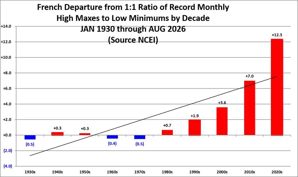
All of the data listed below is part of this one chart. The ratio of monthly record high maxes to low minimums for the 2020s, so far, is higher than any decade since the 1930s:
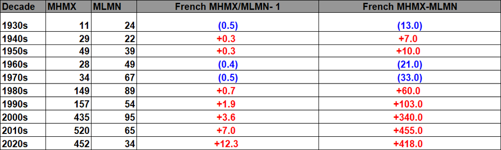
Here are the current French monthly record counts per decade (including ties):
The French daily record data show a strong relationship between temperature anomaly and the balance of warm versus cold records. Negative anomalies favor cold records, while increasingly positive anomalies shift the balance toward warm records. Individual anomaly bins vary because of weather variability, station coverage, and sample size, but the overall progression is clear: warmer conditions produce progressively larger warm-to-cold record ratios.
The monthly datasets show the same physical behavior, although they are somewhat noisier because monthly records are much less numerous than daily records. Warm monthly anomalies generally favor high-temperature records, while cool anomalies favor low-temperature records. This supports the idea that temperature anomaly is a useful explanatory variable for record ratios, rather than the ratios simply changing with the passage of time.
The eventual goal is to turn this relationship into a forecasting tool. If the anomaly-to-ratio relationship can be quantified reliably, a forecast temperature anomaly could be used to estimate the expected warm-to-cold record ratio before a month, season, or year occurs. The next step will be to fit and test that relationship and determine how much uncertainty should accompany each predicted ratio.
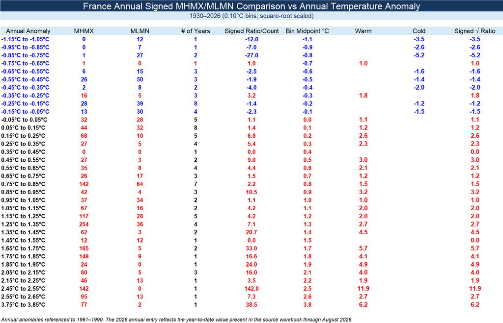
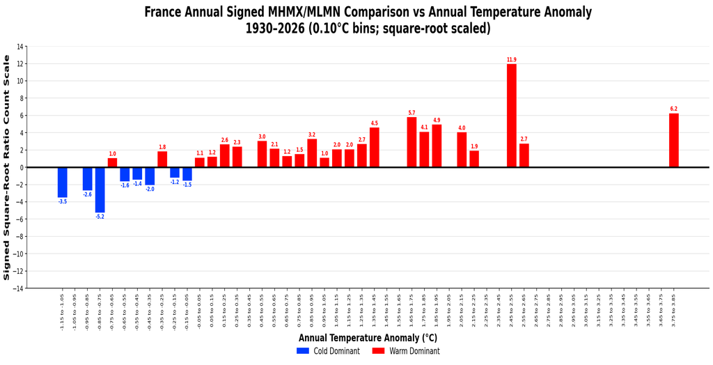
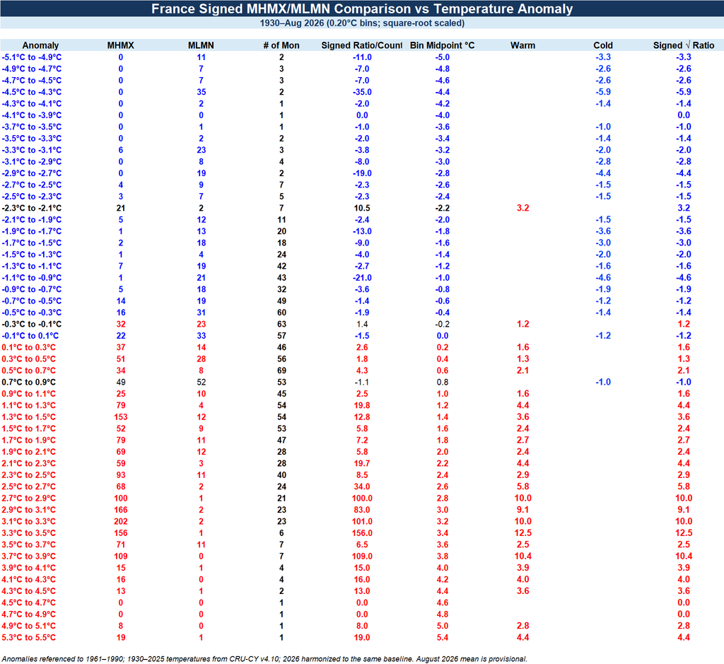
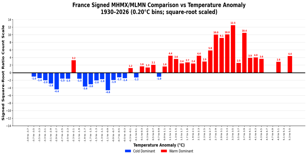
The ratio spikes around moderately strong anomalies because that is where one record type becomes much more common than its opposite while there are still enough observations in the bin to support a large ratio. At the most extreme warm and cold anomalies, events become much rarer, so the sample size falls off and the ratio itself tends to decline. The peak therefore reflects the best combination of strong temperature bias and sufficient record counts, rather than simply the largest anomaly.
The same general behavior has appeared in the U.S. and U.K. datasets. In each case, the record ratios strengthen as anomalies move away from zero, reach their largest values at moderately large anomalies, and then weaken again toward the sparsely populated extremes. That repeated shape across different national datasets suggests that the pattern is not peculiar to France, but may be a broader statistical feature of how temperature anomalies translate into record-setting behavior.
The 2020s:
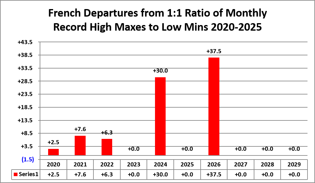
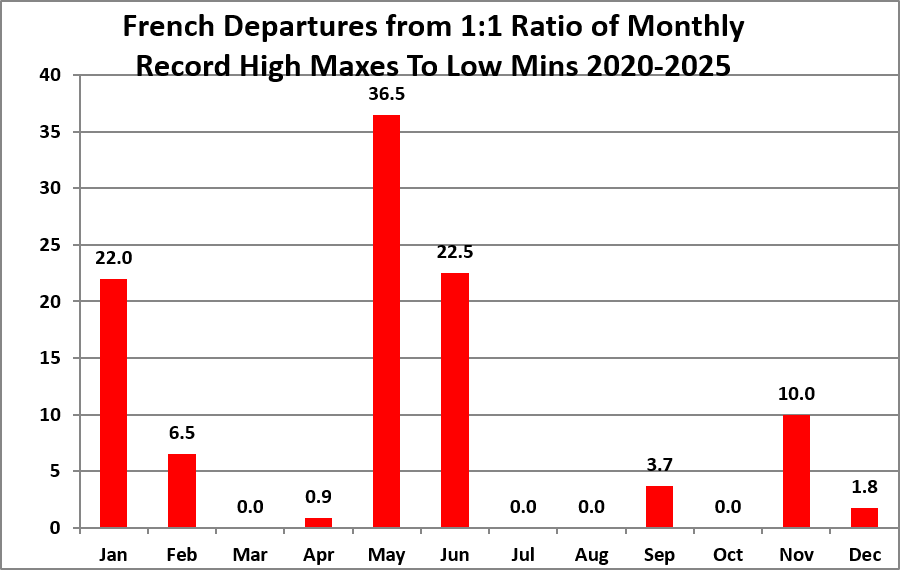
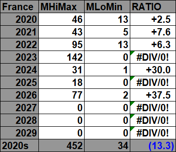
For the above and following datasets of record high maximums and low minimums, blue colors represent cold months and red colors represent warm months. Months with counts close to a 1-to-1 ratio of highs to lows are colored black. National monthly mean temperatures and anomalies for France are based primarily on CRU-CY v4.10 mean-temperature data, with anomalies calculated against the 1961–1990 CRU baseline. For 2026, national monthly averages come from the Météo-France national thermal indicator and are harmonized to that same 1961–1990 baseline. Time stamps showing when record counts were last updated are located in the upper-left corner of each chart.
https://www.statista.com/statistics/771233/temperature-anomalies-france
Also, drop me a note if you see an error or if you have suggestions for improvements.

The 2010s:



The 2000s:



The 1990s:



The 1980s:



The 1970s:



The 1960s:



The 1950s:



The 1940s:



The 1930s:



All of the data listed below is part of this one chart. The ratio of monthly record high minimums to low maximums for the 2000s are higher, so far, than any other decade since the 1930s (mainly due to the 2003 European heatwave):
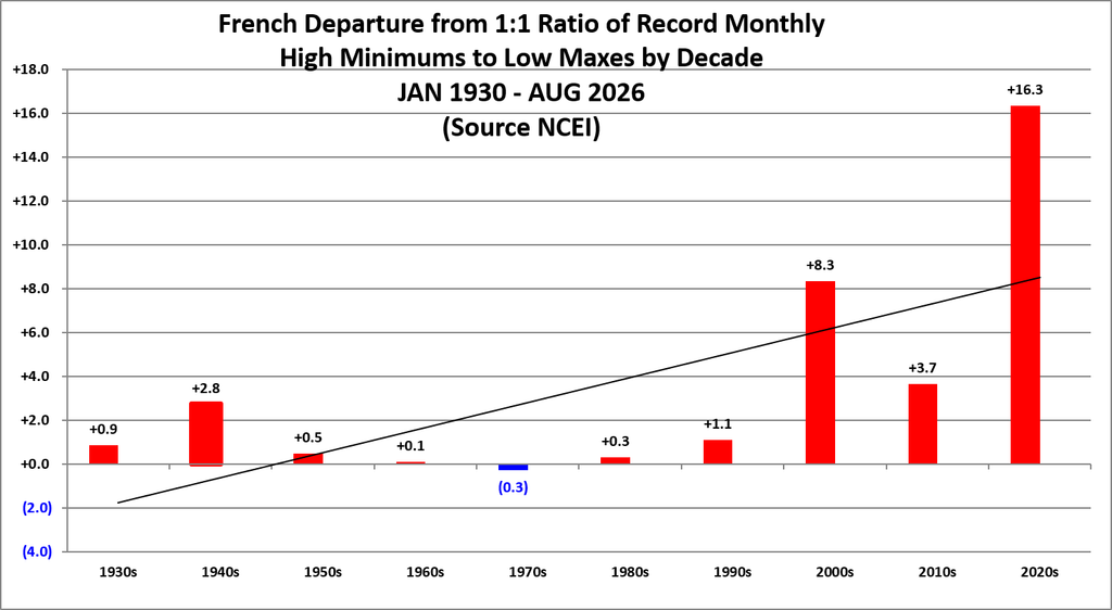
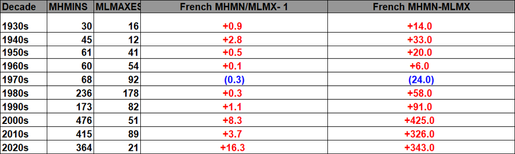
Here are the current monthly record counts per decade:
The French daily record data show a strong relationship between temperature anomaly and the balance of warm versus cold records. Negative anomalies favor cold records, while increasingly positive anomalies shift the balance toward warm records. Individual anomaly bins vary because of weather variability, station coverage, and sample size, but the overall progression is clear: warmer conditions produce progressively larger warm-to-cold record ratios.
The monthly datasets show the same physical behavior, although they are somewhat noisier because monthly records are much less numerous than daily records. Warm monthly anomalies generally favor high-temperature records, while cool anomalies favor low-temperature records. This supports the idea that temperature anomaly is a useful explanatory variable for record ratios, rather than the ratios simply changing with the passage of time.
The eventual goal is to turn this relationship into a forecasting tool. If the anomaly-to-ratio relationship can be quantified reliably, a forecast temperature anomaly could be used to estimate the expected warm-to-cold record ratio before a month, season, or year occurs. The next step will be to fit and test that relationship and determine how much uncertainty should accompany each predicted ratio.
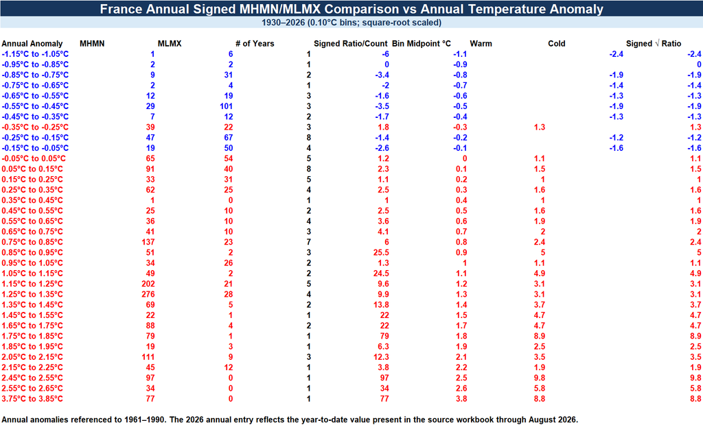
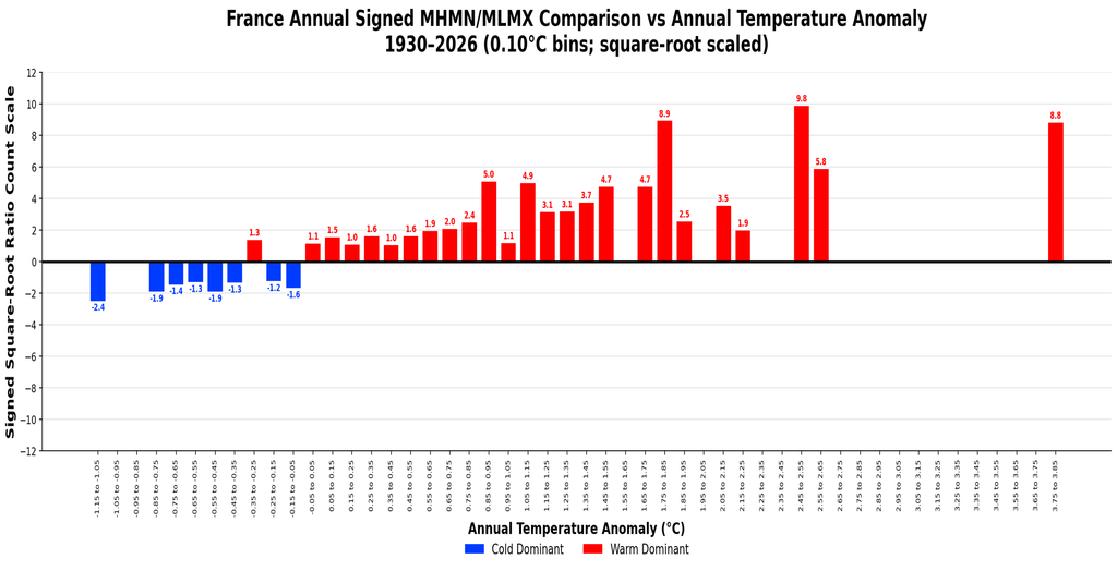
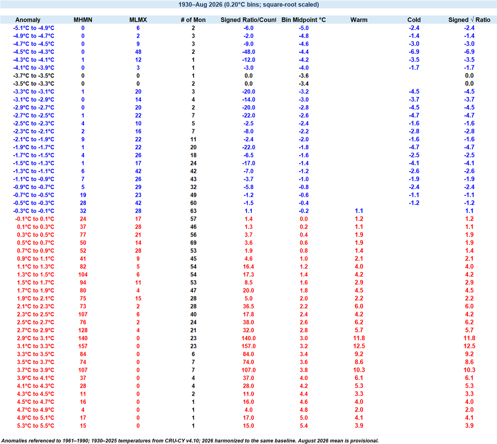
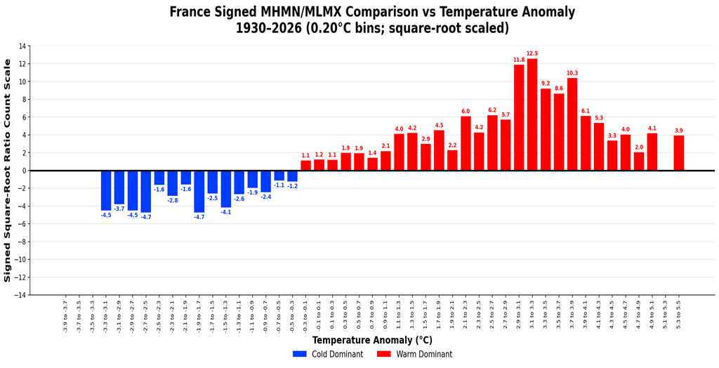
The ratio spikes around moderately strong anomalies because that is where one record type becomes much more common than its opposite while there are still enough observations in the bin to support a large ratio. At the most extreme warm and cold anomalies, events become much rarer, so the sample size falls off and the ratio itself tends to decline. The peak therefore reflects the best combination of strong temperature bias and sufficient record counts, rather than simply the largest anomaly.
The same general behavior has appeared in the U.S. and U.K. datasets. In each case, the record ratios strengthen as anomalies move away from zero, reach their largest values at moderately large anomalies, and then weaken again toward the sparsely populated extremes. That repeated shape across different national datasets suggests that the pattern is not peculiar to France, but may be a broader statistical feature of how temperature anomalies translate into record-setting behavior.
The 2020s:


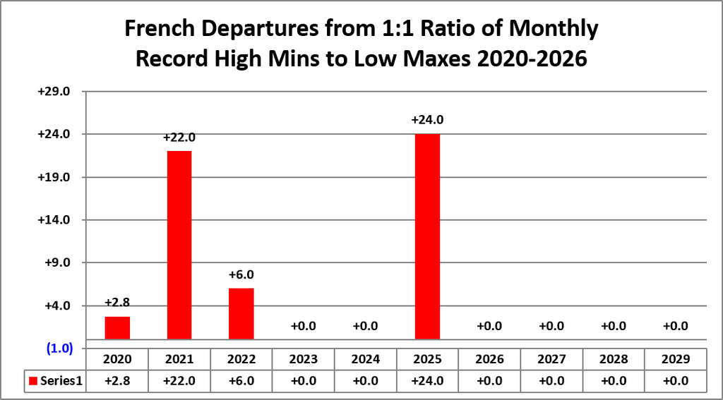
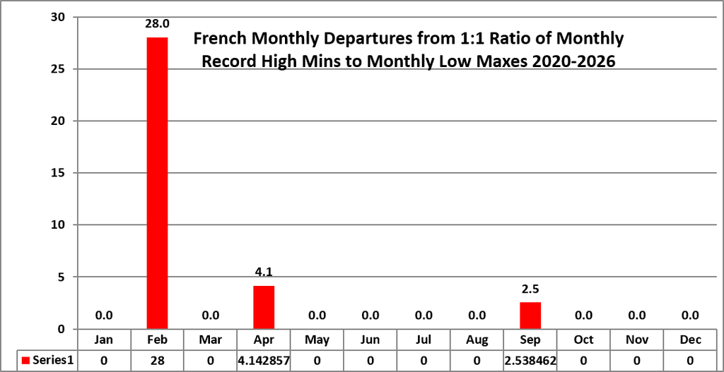
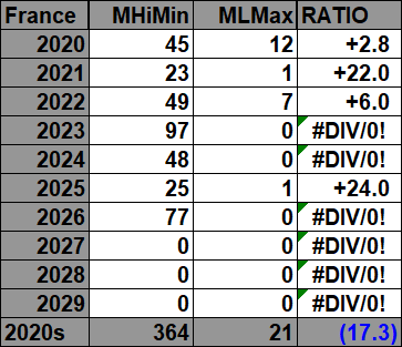
For the above and following datasets of record monthly high minimums to low maximums, blue colors represent cold months, and red colors represent warm months. Months with counts close to a 1-to-1 ratio of highs to lows are colored black. National monthly mean temperatures and anomalies for France are based primarily on CRU-CY v4.10 mean-temperature data, with anomalies calculated against the 1961–1990 CRU baseline. For 2026, national monthly averages come from the Météo-France national thermal indicator and are harmonized to that same 1961–1990 baseline. Time stamps showing when record counts were last updated are located in the upper-left corner of each chart.

The 2010s:



The 2000s:



The 1990s:



The 1980s:



The 1970s:



The 1960s:



The 1950s:



The 1940s:



The 1930s:



These are all of the NCEI counted French monthly record reports. going back to 1930.
Guy Walton…”The Climate Guy”