Tuesday June 20th… Dear diary. Today it is the summer solstice, so we are getting into prime time for dangerous heat across the U.S. Already in June we have seen a week of high heat in the Northeast and are in the midst of a prolonged heatwave in the Southwest. See my prior logs here noting the well forecast job meteorology models did on the buildup of heat in the Southwest:
https://guyonclimate.com/2017/06/14/summer-2017-heat-diary-log-3-june-14-20/
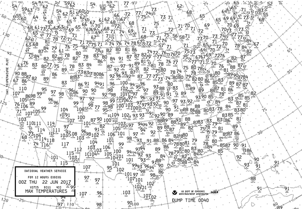
Here are today’s maxes at major reporting stations. Tropical storm Cindy cooled the central Gulf Coast area. Readings got a little higher than expected in the western High Plains:

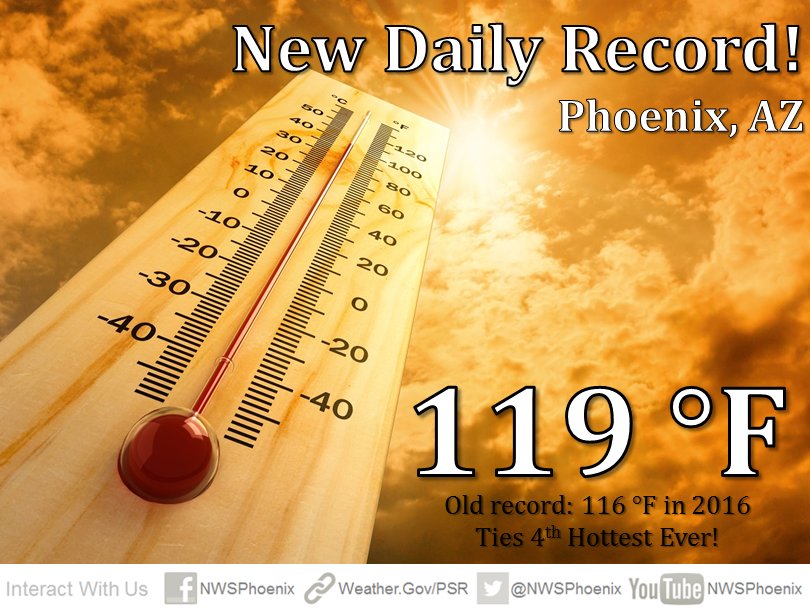
As forecast, the southwestern heatwave should be at its zenith today. All eyes were on Phoenix where the max was 119F, which was a degree hotter than the blistering reading of 118F on Monday. Vegas saw their all-time max tied at 117. It was hot enough, partially due to carbon pollution, to cancel flights: https://www.usatoday.com/story/travel/nation-now/2017/06/19/its-so-hot-phoenix-they-cant-fly-planes/410766001/
Let me clarify the prior statement. This southwestern heat wave has been exacerbated by carbon pollution. We are writing about the desert, after all, but the greenhouse effect due to excess CO2 makes the heat that much worse.

What about tomorrow? Here is the latest Intellicast chart generated from the GFS model:

More record heat will occur in the Southwest, but maxes should be a degree or two lower than on Tuesday. Near record heat will build in the Rockies and High Plains. The rest of the nation should not have record heat. This is the forecast from the Boulder, CO NWS:

Will the heat spread eastward as this week continues? The answer is no. In fact, the shot of cool air moving into the Midwest will probably set a few record lows by this weekend looking at 850 Mb temps:
 I’ve concluded that until the planet gets above that +2C anomaly plateau the nation will see record cool or cold conditions from time to time; however, heat will trump chill in the meantime due to carbon pollution. I think that 30 month streak of more daily record highs than lows is safe this month.😉
See: https://guyonclimate.com/2017/05/31/building-a-better-method-to-forecast-dangerous-heat/
I’ll update this post through the evening as more information comes in.
An update: At the heat capital of the U.S. it got up to 127F at Death Valley: (Image from Mike Tarello)

We’ll see if it gets any hotter at Death Valley the next few days.
The Climate Guy
__________________________________________________
Wednesday June 21st… Dear diary. The following is a more detailed account of the impressive list of records from yesterday in the Southwest from MDA Weather Services:

I’ve already indicated that the southwestern record heat peaked yesterday, but that does not mean the heatwave is over by any means. Meteorologists look for what I will term “upper ridge persistence and strength” to determine the length and severity of a heatwave. Unfortunately, even though 500 Mb heights do come down a notch for a couple of days, the ridge parked over New Mexico and Arizona does persist well into next week.
In my 30+ years of watching summer weather patterns usually by early June if a ridge gets established in one area of the country, it is stubborn to break down and persists for much of the summer. This seems to be particularly true for southwestern ridges. This chart is valid for Monday:

I would anticipate many more record highs to fall over the next week in the Southwest.
Also, note the blue depiction on that 500 Mb Pivotal Weather chart across the Great Lakes. The mean temperature hasn’t gotten so warm across the planet that cooler or even much colder than average air can move into the CONUS. Using meteorology terms, old teleconnection, long wave patterns in the troposphere still hold. Usually if there is a big ridge or mid-level high in the West there will be a corresponding trough in the East ushering in cool air in the summer and cold air in the winter. Such will be the case next week.
Does this persistent long wave pattern of a ridge in the West and trough in the East mean that much of the nation east of the Rockies is off the hook for exceptional, prolonged heat this year? We will see.
Updates: Record reports are starting to pour in from the West. Yep it’s been rather toasty:

Phoenix set another record despite the expected cooling😉 trend. Vegas set a daily record high of 114F breaking the old record of 113F set just last year.

One area that may be just as hot the next few days is the Sacramento Valley. This is a good caption from the NWS Sacramento depicting how high the current heat wave risk is for the general population:

To get a better idea of how hot the Desert Southwest will be during the heat wave look no further than Needles, CA:

If forecasts are correct, according to Eric Fisher, Needles will reach or exceed 120F for seven straight days, which I’ll keep tabs on. The current record is only three.
Wow! Speaking of dry and hot, I saw this tidbit from Eric Blake today about Needles, CA. I too have never seen a reading of 120F with a dewpoint of -11F. I would hate to be dehydrated in this:

Here are today’s maxes for major reporting stations that gets processed every evening by about 9:30 PM EDT:

As expected near record heat occurred from west Texas northward through the western High Plains northward into Nebraska. I’m sure that many record highs were set throughout the Rockies in contrast to snowy conditions and record cold that occurred in late May.
What about Thursday? Here are the latest GFS generated model numbers from Weather Services International:

Cooler air will nose southward through the Front Range. It will generally be a couple of degrees cooler in Nevada and Arizona, but maxes will still be near record levels. California will still be blazingly hot. The rest of the nation will fair well with no record heat on Thursday.
Another update: Uh-oh. The heat wave has claimed two seniors in the San José area according to the L.A, Times:
http://www.latimes.com/local/lanow/la-me-ln-heat-wave-death-san-jose-20170621-story.html
The Climate Guy
____________________________________
Thursday June 22…Dear diary. Hundreds of record reports are beginning to come into the NCEI database due to the southwestern heat wave. The ratio of daily record high records to daily record lows sits at over 3 to 1 and is climbing for June 2017:

The only hope for the “cold team” to break that 30 month and counting streak will be the cool shot of air coming into the Midwest next week. I seriously doubt that over 1,000 daily record low reports will come from the cool shot so on we go through the summer months raking up hotter than average months for the CONUS…a clear sign that something is off affecting the environment. I wonder what that could be?😉
Evening Update: Fascination record tidbits are being reported. The most glaring is the fact that Tucson, AZ has had three days in a row of maxes at 115F+. Prior to this southwestern heat wave Tucson has had only four days of temperatures as high as 115F:

Here are Thursday’s highs:

The “cooling” trend continues in Arizona but not so much elsewhere un the Southwest. It failed to get to 115F in Tucson for the fourth straight day. Near record heat continued in the western High Plains.
_________________________________________________
Friday June 23…Dear diary. The western heat wave will expand into the Pacific Northwest this weekend. Remember what I stated earlier this month? The nose of the highest 500Mb anomalies point to where high heat may occur. This MDA Weather Services chart shows where our strong ridge is bulging:

MDA Weather Services also state that they are expecting Portland’s 8th 100F reading on record during the month of June this weekend (since 1941). This Intellicast chart shows the model guidance where they are getting this forecast:

What is the extent of the area across the CONUS under heat advisories or warnings ATTM? Here is the latest national NWS advisory chart:

Most of the nation is getting a nice break from early summer heat except Texas , New Mexico, Arizona, and the far West. Even though the heat has come down a notch in most warned locations, dangerous conditions will persist through the weekend.
This evenings updates:
Perspective from Eric Holtaus: 110°F+ days in Tucson, by decade:
1940s: 3
1950s: 4
1960s: 1
1970s: 2
1980s: 15
1990s: 36
2000s: 11
2010s: 17 (including 3 this week, so far)
From Rob Ellington, Redding CA had a max of 110F and a min of 86F for an all-time warm average of 98F today.
From Sam Argier, Las Vegas NV either tied or set a record for the fourth day in a row:

Here are the national highs for major stations across the U.S. for Friday:

It was much cooler across the Front Range. It got up to the century mark across much of Texas.
I’ll be adding to this post as more record tidbits come in today.
To see all 2017 Heat Diary entries click:
https://guyonclimate.com/category/heatdiary2017/
The Climate Guy