Monday July 23rd…
Dear diary. In the last couple of weeks there have been dire media articles forecasting humanities demise should carbon pollution go unchecked and not be very substantially limited as we roll along through the 21st century. At the very least there are forecasts that some areas of our planet will become “uninhabitable” meaning that it will get so hot that without some sort of life support system people could not survive outdoors. The best weather historian I know, Chris Burt, has come to the conclusion that uninhabitable zones will be popping up on the Earth, the first being in portions of the Middle East:
http://www.vanityfair.com/news/2017/06/extreme-heat-global-warming
My own take is that in the United States the two largest and most vulnerable cities that will be increasingly stressed are Las Vegas and Phoenix as maxes in these locations begin to exceed 120F more frequently during the summer. The Desert Southwest, as we have seen signs of this summer, could get so torrid that some days just going outside briefly could be lethal. For now, air conditioning keeps even the hottest areas of the desert livable, but at what point will temperatures be just too hot?
Today Dr. Michael Mann, now the foremost expert on climate change, came out with an article suggesting that humanity has very little wiggle room when it comes down to how much more carbon pollution can be emitted before its too late to do much about the environment:
https://phys.org/news/2017-07-carbon-overestimated.html
The main item in contention here is defining what carbon level in the atmosphere is marginally healthy to maintain current sea and heat levels, if possible. Is it the “preindustrial level” defined as that of the late 19th century or the dawn of large scale industrialization that occurred much earlier in time when carbon levels were around 280 ppm?
This graph is a sobering reminder of what mitigation has done to the rate of rise of carbon in the atmosphere (practically none I can see here after each global treaty, unfortunately):

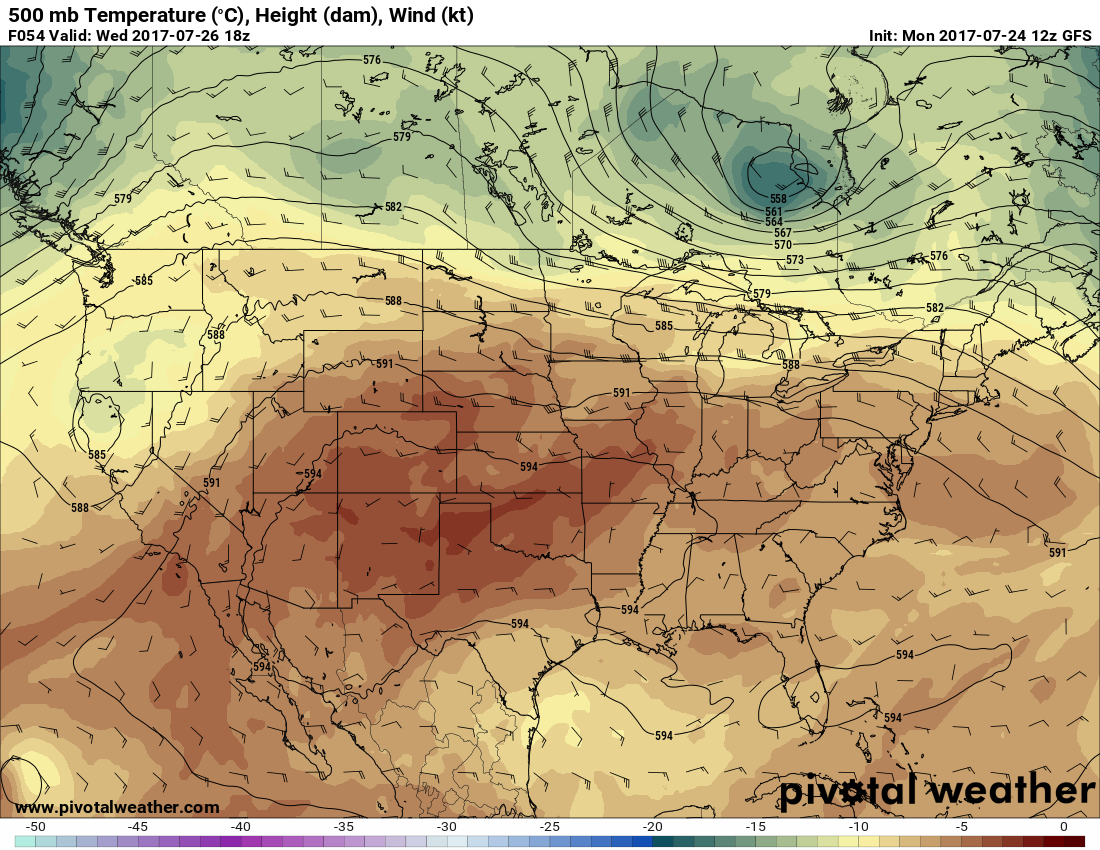
We’ll delve into these questions in time on this site. For now let’s look at very short term heat forecasts in the U.S. It looks like our fourth heat wave of the season will be making a brief comeback in the Plains and South as 500 Mb heights rise from what the are now:
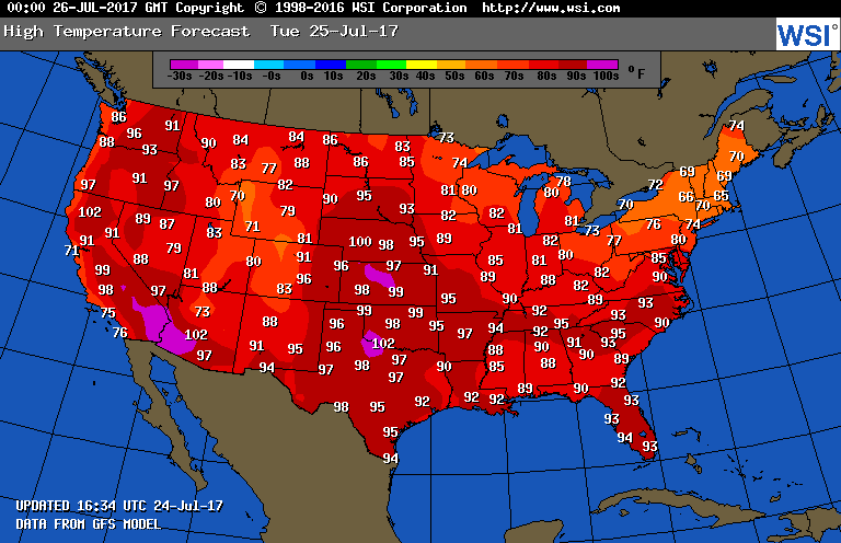
Here are the forecast maxes for Tuesday. We should see higher maxes than what is depicted in the Plains:
Monday Evening Updates…
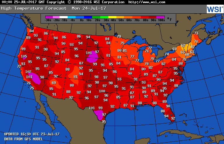
Here were today’s maxes:

Our heat wave continued in the Plains. The monsoon “cooled” Phoenix to 90. Oh so close! Denver missed a record high by one degree:
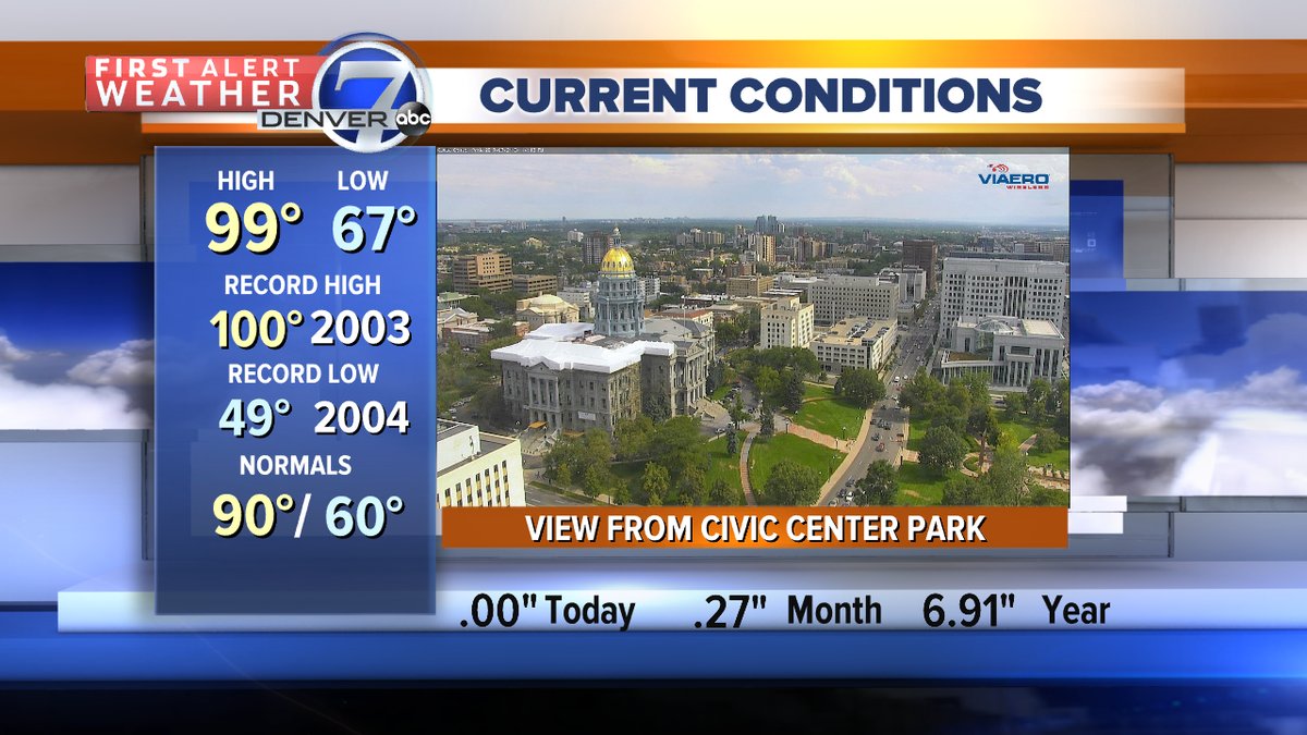
(Image from Mike Nelson)
The Climate Guy
Sunday Evening Update…
Here are today’s national maxes:

Although still hot, temperatures have cooled substantially in the central Plains and Missouri from what they were on Saturday. Oklahoma and Texas were the hot states east of the Rockies. Expect about the same temperature pattern across the U.S. on Monday.
The Climate Guy
Sunday July 23rd…
Dear diary. The fourth heat wave of the season is ever so slowly diminishing east of the Rockies. Today I will give the reasons why this heat wave will eventually disappear from the East and rebuild again in the West.
To start off this week heat advisories have been paired out of the Upper Midwest and are now confined to the Mid-Mississippi Valley, southern Plains, and Middle Atlantic. There are some advisories also in the heat ravaged West:

Tomorrow any dangerous heat should be confined to the central and southern Plains, Southeast and, as usual, lower elevations of the West. We can use these numbers as a guide, although the Plains should be a few degrees hotter than what is shown here:
Another rough rule of thumb I use to forecast dangerous heat is the 588 decameter line on models during the summer. Usually any area north of 588 decameters is at or below 90F, and out of the danger zone, except in the West. Let’s check the above chart with what we see at 18Z Monday:

Walla, the rule of thumb is pretty close. A trough with heights below 588 decameters has put the kibosh on any heat from the Great Lakes into the Northeast.
What about the rest of this week? Ensembles support the idea of our southern Plains ridge retrograding West, strengthening as it does so. By the end of this week another system will dig into the Great Lakes, and this one looks pretty strong for this time of the year. By Saturday, looking at the more reliable European model, we should approximately see this pattern:

There is a lot of good news here. The air mass coming into the East behind the Great Lakes system will be unseasonably cool and should penetrate southward all the way to the Gulf Coast. It has been my 30+ year experience that when such a change occurs in late July, I have never seen a heat wave of any great magnitude make an appearance east of the Rockies during August. By no means is this “the end of summer”, but extreme, record breaking heat won’t be too likely, especially from the Midwest into the Northeast.
In the meantime I would expect the Plains and Southeast will be contending with what’s left of heat wave #4 into next weekend. Also, once we do see the coming change, the West will probably be contending with yet more extreme heat. Stay tuned.
I’ll be adding to this post with updates later today.
To see all 2017 Heat Diary entries click:
https://guyonclimate.com/category/heatdiary2017/
The Climate Guy
In St. Joe Missouri yesterday the heat index hit at least 119F, and was the fourth day in a row with heat index values reaching at least 111F, any thoughts on how modern corn production over a large area might be affecting heat waves in the mid section of the country? KC has not officially hit 100F at thier air port since 2013, but I wonder if the excess moisture in the air from modern ag. Could be holding down 100F degree days in already humid summers, even if just by a bit?
Hey Nick,
Modern corn production has definitely affected temperatures and humidity where it is grown in great quantities. If maturing and not stunted by drought corn acreage becomes a microclimate adding moisture to lower levels of the atmosphere. Through cloud physics humidity, and thus the Heat Index, goes up while temperatures stay a little lower than what the would be on grassland.
Stay cool! Relief should be coming your way soon.
The Climate Guy
Thank you for the reply 🙂 Its amazing how we can have regional/local effects on the climate that are not always apparent on the surface.