Monday October 14th… Dear Diary. The main purpose of this ongoing blog will be to track United States extreme or record temperatures related to climate change. Any reports I see of ETs will be listed below at the very end of this daily blog. I’ll refer to extreme or record temperatures as ETs (not extraterrestrials).😉
U.S. Just Saw Hot/Cold Weather Whiplash Brought About By Climatr Change
Most everyone in the climate and weather world are aware of the extreme heat wave that plagued most of the southern and eastern U.S. from August until October 6th. The phenomenon produced a “flash drought,” which so far has affected agriculture, particularly in the Southeast:

Not too many people in the East and South are aware of the subsequent cold wave and blizzard in the northern Plains, dubbed Aubrey by The Weather Channel, that produced exceptionally low temperatures in the Rockies. It’s not very often that all-time record lows get established in early October. Nevertheless, as of today I see the following all-time record counts stats (from the last 30 days):
https://www.ncdc.noaa.gov/cdo-web/datatools/records
High Maxes: 2. High Minimums: 1. Low Maxes: 34. Low Minimums: 62.
In a real sense based on all-time record counts the cold wave was more extreme than the heat wave.
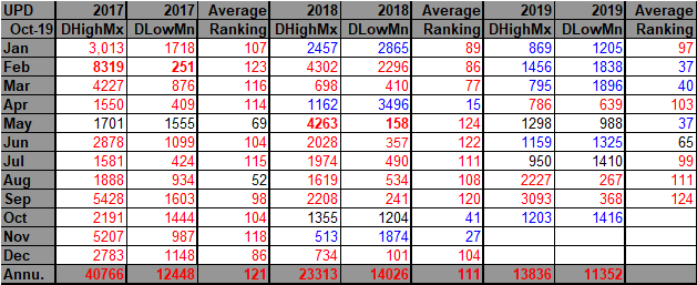
Here is a “before” cold wave “Record Scoreboard” through 10/6/2019:

Now the “after” “Record Scoreboard” updated through 10/12/2019 in NCEI’s system:
The cold wave began on 9/30 producing enough record low counts to knock September 2019 out of the bold red, more than a 10-1 DHMX to DLMN record status. We now see a substantial more daily record low count in October 2019 giving us another blue month, so far.
Both extreme cold and heat in very large pockets have ended for the time being across the United States.
Here are animations of the cold wave interacting with what was left of the heat wave earlier this month
And from one guy I personally know who experienced the cold wave first hand in Boulder, CO:
During the heat wave the Washington Post saved this image of the 500 millibar pattern:

The cold, blue trough was the culprit for Aubrey and also brought about the cold wave. I and Dr. Michael Mann contend that the weakening polar vortex due to climate change is allowing occasional cold troughs to get pinched off far to the south…a phenomenon picked up by a younger person than my generation with a doctorate, who hasn’t necessarily agree with all tenants of AGW theory in the past:
We will probably experience whip-lash, hot-cold weather conditions across the planet during fall through spring across the planet for the foreseeable future. The worst factor, well beyond a miserable inconvenience for most, will be effects on farming and water supplies during the most extreme cycles of hot and cold weather. Stay tuned to the Extreme Temperature Diary to see the ups and downs from our new climate change roller coaster.
Here is more climate and weather news from Tuesday:
(As usual, this will be a fluid post in which more information gets added during the day as it crosses my radar, crediting all who have put it on-line. Items will be archived on this site for posterity. In most instances click on the pictures of each tweet to see each article.)
Here is one warm “ET” from Monday:
(If you like these posts and my work please contribute via the PayPal widget, which has recently been added to this site. Thanks in advance for any support.)
Guy Walton- “The Climate Guy”