The main purpose of this ongoing blog will be to track planetary extreme or record temperatures related to climate change. Any reports I see of ETs will be listed below the main topic of the day. I’ll refer to extreme or record temperatures as ETs (not extraterrestrials).😉
Main Topic: Update On Winter Storm Xylia
Dear Diary. Last Saturday and Sunday all meteorological models were forecasting a major hybrid winter/spring storm to affect the nation’s heartland, which I wrote about in the following post:
It’s time for an update a day before what The Weather Channel has dubbed Xylia gets cranking.
The system has already produced some havoc in California:
At this point it looks like we will still see heavy rain that could lead to flooding along a stationary front that will stretch from the central Plains into Missouri, but we probably won’t see totals heavy enough to put whole towns under water. Therefore, Xylia may not be a historic storm known for its flooding, and the Midwest may luck out, not seeing a climate change related disaster.
I have more good and bad news today. At this point it looks like Xylia will produce very beneficial precipitation in the Rockies and western High Plains, which are undergoing a severe drought. The bad news is that snow will be measured in feet in some locations. We could be looking at a top five ranked March snowstorm for portions of the Rockies once the snow ends by Monday.
My buddie, renowned climate science writer, Bob Henson who reside in Boulder Colorado, is pretty giddy about Xynia. Keep in mind that climatologically Denver receives its heaviest snow in March:
For another take on what Xylia may do let’s repost some of what Jeff Berardelli has been writing. Jeff is one of my favorite weather and climate broadcasters:
https://www.cbsnews.com/news/snow-storm-winter-weather-tornadoes-rockies-plain-states/
Monster storm to bring several feet of snow and tornadoes this weekend
BY JEFF BERARDELLI
MARCH 11, 2021 / 6:46 AM / CBS NEWS
A slow-moving, blockbuster storm is likely to bring the biggest snowfall in decades to parts of the Front Range of the Rockies and western Plains states this weekend, possibly challenging all-time records for some cities. On the warm side of the storm, the first spring season severe weather outbreak threatens Texas, Oklahoma and Kansas.
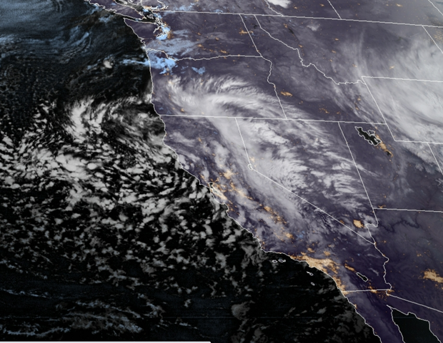
The massive, whirling storm system was diving southward from the Pacific Ocean into California on Wednesday, providing some much-needed rain and snow after the fourth-driest 18-month stretch in state history. Heavy downpours will bring an inch or two of rain to many parts of the state and over a foot of snow in the higher elevations.

NOAA
Once the storm reaches the Rockies it will slow down and intensify, using its atmospheric dynamics to funnel warm, moist air from Mexico northward — slamming the moist conveyor belt right into elevated land in the western Plains and Rocky Mountains. This effect of forcing air to rise due to land elevation is called orographic uplift and is responsible for the biggest snowstorms in cities like Denver and Boulder.
While the first round of snow is falling Wednesday in Colorado, Wyoming, Nebraska and South Dakota, it’s the next round, starting later Friday and reaching its apex on Sunday, that will make traveling near impossible, with snowfall rates of 2 to 4 inches per hour. Wind gusts over 45 mph are likely on Saturday, ramping up to 60 mph on Sunday, meaning blizzard conditions will be widespread.
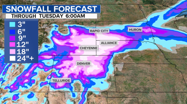
It’s still early, but computer models see the bullseye of heaviest snowfall stretching from Denver and Boulder in Colorado northward into Cheyenne and Casper, Wyoming and northeastward into Scottsbluff, Nebraska and Rapid City, South Dakota. In these areas, 2 to 3 feet of snow may be common. There’s even some chance that isolated locations will pick up as much as 50 inches of snow during this elongated, six-day series of weather events.

CBS NEWS
Although it is too soon to know for sure, early indications are that all-time snowfall records may be threatened. That is just as much a product of how slowly the storm is projected to move as it is an indication of the intensity of the storm.
Like many past heavy snowstorms in this part of the nation, it is being caused by something known as a cut-off low. This is a system that is generally cut off from the forward steering of the jet stream. In this case the storm is trapped underneath a warm ridge of high pressure in Canada which acts as a block, allowing the storm to persist for days.
This type of setup is how Boulder, Colorado, set its all-time heaviest 24-hour snowfall record exactly 100 years ago. Like this weekend, a Pacific storm became trapped for days to the south of a stubborn mountain of warm air to its north. That storm in 1921 ended up producing about 100 inches of snow in 4 days.
Denver’s largest snowstorm was in December of 1913 when nearly 46 inches of snow fell. More recently, in a 2003 storm, the city got 31.8 inches. It is not a stretch to say that Denver may see its heaviest snowfall in 18 years or longer this weekend.
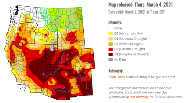
This is not all bad news. Right now, the majority of the West is experiencing one of its worst droughts on record, with much of the region in extreme or exceptional drought conditions.

US DROUGHT MONITOR
Severe storms and tornado threat
On the warmer, eastern side of the storm, it’s becoming more clear that the system will bring with it the first severe weather event of the season. That means areas from west Texas into Oklahoma and southern Nebraska will need to be on the lookout for severe storms, large hail, damaging winds and tornadoes Friday through Sunday.
On Friday the biggest threat will be from west Texas, near Lubbock, into western Oklahoma. On Saturday and Sunday that threat will shift east towards Oklahoma City and Dallas.
The storm will finally begin to pull away on Monday, bringing with it heavy rain for mid-Missouri and mid-Mississippi Valley areas, where several inches of rain are possible from Thursday into the middle of next week. Residents should be aware of the risk of river flooding.
First published on March 10, 2021 / 11:04 AM
© 2021 CBS Interactive Inc. All Rights Reserved. Jeff Berardelli
Jeff Berardelli is a meteorologist and climate specialist for CBS News.
Since there has been precedent for this type of storm in March, despite a lot of warmth at the surface and aloft near the system, there probably isn’t much of a climate change connection signal here, but I’ll report any that can be made. I’ll have more updates over this coming weekend on Xylia.
Here is some more February 2021 climatology:
Here is more climate and weather news from Thursday:
(As usual, this will be a fluid post in which more information gets added during the day as it crosses my radar, crediting all who have put it on-line. Items will be archived on this site for posterity. In most instances click on the pictures of each tweet to see each article. The most noteworthy items will be listed first.)
Now here are some of today’s articles and notes on the horrid COVID-19 pandemic:
(If you like these posts and my work please contribute via the PayPal widget, which has recently been added to this site. Thanks in advance for any support.)
Guy Walton “The Climate Guy”