The main purpose of this ongoing blog will be to track planetary extreme, or record temperatures related to climate change. Any reports I see of ETs will be listed below the main topic of the day. I’ll refer to extreme or record temperatures as ETs (not extraterrestrials).😉
Main Topic: Earth’s Average Temperature Is About to Spike
Dear Diary. An El Niño is developing in the Pacific which will spike global temperature averages toward that dreaded +1.5°C (2.7°F) level above preindustrial conditions. We can see an El Niño developing looking at sea surface anomaly charts off the coast of South America. The red area there is quite startling:

So, we should an El Niño soon:
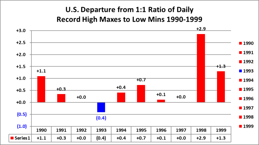
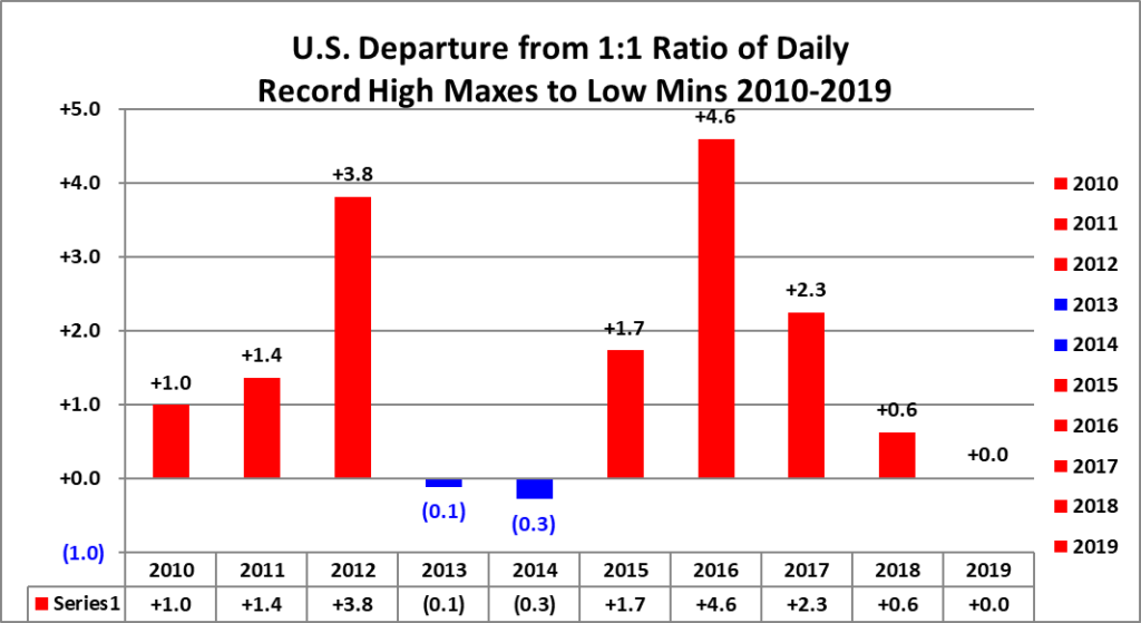
Not only do El Niño’s spike global sea surface temperature averages, but they also influence our climate by warming the lower atmospheric temperature worldwide. We saw the influence of record strong El Niño’s across the United States in 1998 and 2016, spiking ratios of warm to cold reports (Source NCEI):
Already Peru is being influenced by warm waters off of their coast:
It’s uncertain how strong the next El Niño will be or how long it will last. Our science is just now beginning to make better forecasts concerning ENSO (El Niño – Southern Oscillation), but strength and longevity forecasting ability needs a lot of work. What’s alarming this time around is that global average temperature levels are near record high levels in the absence of El Niño. Here are more details from Matthew Cappucci writing for the Washington Post:
Earth experienced its second-warmest March on record – The Washington Post
Earth has second-warmest March even before arrival of planet-heating El Niño
It was the 529th consecutive month to feature temperatures above the 20th-century average

April 7, 2023

A look at temperature anomalies for March 2023. (Copernicus ECMWF)
March 2023 will go down in the books as tying for the second-warmest March on record. That’s according to the Copernicus Climate Change Service of the European Union. Temperatures globally were several degrees above average in most places outside the western United States, where a stagnant weather pattern allowed cooler than typical readings to hang around most of the month.
The unusually warm month occurred even before the projected arrival of the El Niño climate pattern, which increases global temperatures.
Still, the relatively warm month is consistent with the expectations of climate scientists amid a swiftly warming environment. March represents the 529th month in a row with temperatures exceeding the 20th-century average. That’s more than 44 years straight without a single comparatively cool month.
“These March statistics are not surprising, as we’re breaking monthly records almost [every] year now,” Kim Cobb, a climate scientist and professor of environment and society at Brown University, wrote in an email.
March by the numbers
Copernicus determined that the March global average temperature was 0.92 degrees Fahrenheit above the 1991 to 2020 normal. This warmth helped last month tie with 2017, 2019 and 2020 as the second-warmest month on record. There still exists a substantial gap of about 0.2 degrees, between March 2023 and the current first-place record holder, which is March 2016.
A strong El Niño pattern was present in March 2016, boosting temperatures. El Niño begins as a warming of ocean waters in the eastern tropical Pacific, which warms the surrounding air and shuffles weather patterns across the northern hemisphere and beyond. Global temperatures tend to be higher during periods dominated by El Niño.
At present, ENSO, or the El Niño Southern Oscillation — the overarching pattern that oscillates between El Niño and La Niña — is in a neutral state. In other words, we’re at the midpoint between both extremes, without any particularly prominent push in either direction. That’s what makes the current level of warmth stand out.
“What I still find shocking is that the last eight years were the eight warmest years on record,” Cobb said. “That’s truly exceptional, given that year-to-year temperatures are impacted by natural variations associated [with] El Niño’s and La Niña’s.”
The extent of Arctic and Antarctic sea ice was also well below average during the month, flirting with record lows in both hemispheres.
“For a while, there were dynamical effects related to El Nino/La Nina, and changing wind patterns, that left Antarctic sea ice relatively unchanged even in the face of record decreases in Arctic sea ice,” Michael Mann, a professor of climate science at the University of Pennsylvania, wrote in an email. “But the effects of a warming planet, and in particular the record ocean warmth we documented earlier this year … is clearly now winning out.”
Floating ice around Antarctica just hit a record low
March in the United States
In the United States, March was a mixed bag. The western part of the country experienced temperatures several degrees below average, whereas considerable mildness was present most of the month over the East. Boston, for example, was 2.5 degrees above average, New York was 1.8 degrees above average, Washington was 1.5 degrees warmer and Atlanta ran 2.4 degrees on the mild side.
On the West Coast, however, the pendulum swung in the opposite direction. San Francisco was 3.3 degrees below normal, Los Angeles ran 3.6 degrees cooler, Denver was 5.7 degrees below average and Albuquerque was 3.5 degrees chillier.

March temperature departures compared to average. The obvious cross-country divide is clear. (Southeast Regional Climate Center)
That cross-country clash — characterized by a frigid West and warm, humid East — allowed repeated rounds of violent storms over the central states and South. The month ended with a tornado outbreak that carried into April 1, with 123 tornadoes confirmed thus far. The United States has seen about 60 tornado deaths this year, which is more than twice last year’s total.
While the National Oceanic and Atmospheric Administration hasn’t yet announced how temperatures over the U.S. compared to historical averages, February, which featured a similarly divisive weather pattern, still averaged out 2.7 degrees above normal, and January was a staggering 5.1 degrees ahead of average.
What the warmth means
Worldwide, March came on the heels of the fourth-warmest February on record. Before that, January was the seventh-warmest on record. Considering a recent La Niña was subduing the expression of underlying warming affecting the atmosphere, it’s likely that the upcoming El Niño pattern will catapult the planet into a reliable spot near the top of the leader board over the coming months.
Sea surface temperature differences from normal worldwide in the tropics and subtropics, between 60 degrees north and 60 degrees south of the equator, are at a record for April, according to the University of Maine’s Climate Reanalyzer.
In mid-March, average ocean water temperatures surpassed 70 degrees for the first time on record.

A look at global sea surface temperature anomalies between 60 degrees north and south latitude. (University of Maine)
With El Niño expected to take the reins soon, there’s a majority chance that 2023 ends up as one of the top five warmest years on record.
“If even a moderate El Niño materializes in 2023, it could very well usher in a new global temperature record, beating out 2016, which was a very strong El Niño event,” Cobb said.
Since preindustrial times, Earth has warmed 1.9 degrees, and there’s no sign of that slowing anytime soon. Copernicus projects the Earth will eclipse 2.7 degrees (1.5 Celsius) of global warming by August of 2034.
Jason Samenow contributed to this report.

By Matthew Cappucci Matthew Cappucci is a meteorologist for Capital Weather Gang. He earned a B.A. in atmospheric sciences from Harvard University in 2019, and has contributed to The Washington Post since he was 18. He is an avid storm chaser and adventurer, and covers all types of weather, climate science, and astronomy. Twitter
Here are some “ET’s” recorded from around the planet the last couple of days, their consequences, and some extreme temperature outlooks, as well as any extreme precipitation reports:
Here is some more new March 2023 climatology:
Here is more climate and weather news from Monday.
(As usual, this will be a fluid post in which more information gets added during the day as it crosses my radar, crediting all who have put it on-line. Items will be archived on this site for posterity. In most instances click on the pictures of each tweet to see each article. The most noteworthy items will be listed first.)
If you like these posts and my work please contribute via the PayPal widget, which has recently been added to this site. Thanks in advance for any support.)
Guy Walton… “The Climate Guy”