The main purpose of this ongoing blog will be to track planetary extreme, or record temperatures related to climate change. Any reports I see of ETs will be listed below the main topic of the day. I’ll refer to extreme or record temperatures as ETs (not extraterrestrials).😉
Main Topic: Heatwave Gasprom Fades in the West but Continues to Bake the East
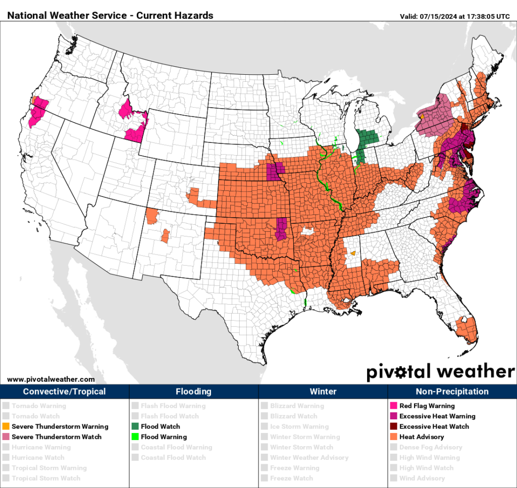
Dear Diary. After early this week the United States is going to see a break from extreme heat that has been broiling the nation since the start of summer. Already in the West National Weather Service heat advisories have been dropped because the heat dome there has diminished, and some moisture has moved into the region lowering temps. Not so in the Plains and East as of this Monday where record temperatures from Heatwave Gasprom are combining with high humidity to make life miserable for many. Of course, as my readers know, I name all major U.S. heatwaves after oil companies to highlight their culpability for making heat episodes worse this century.
Due to the collapse of Gasprom’s heat dome by Wednesday, we will soon see a temperature regime that is refreshingly cool for most except in the West:
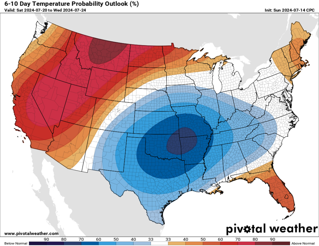
Will Gasprom remain in tact enough go retrograde into the West? Stay tuned.
This Monday I’m highlighting the East, where temps will be peaking today and Tuesday with a Washington article reposted here. One thing to keep in mind. When the cold front that moves in from the Midwest that breaks Gasprom in the East there probably will be severe storms accompanying the system. Record temps plus high humidity will supply plenty of fuel for unwanted fireworks that would not be nearly as potent in a cooler world run by clean energy. Oh well:
Heat wave forecast for 10 cities as dangerously hot weather bakes East Coast – The Washington Post
Brutal heat is blasting the East Coast. Here’s a city-by-city forecast.
More than 100 million people are under heat alerts from Florida to Maine.

July 15, 2024 at 11:15 a.m. EDT
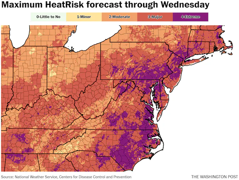
Heat Risk outlook through Wednesday. (Ian Livingston)
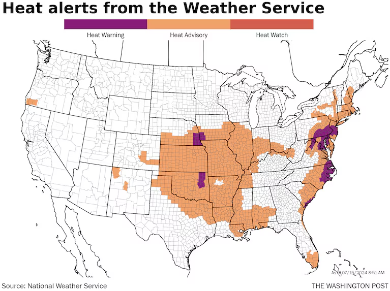
After a 10-day siege of record high temperatures in the western United States, the core of extreme heat has shifted toward the East Coast. To start the new week, about 100 million people are under heat alerts from Florida to Maine, and relief is not expected for several days.
Washington, Baltimore, Philadelphia and much of eastern North Carolina and Southeast Virginia are under excessive-heat warnings, the highest level alert. In these areas, highs are expected to rise to near 100 with heat indexes — a measure of how hot it feels factoring in humidity — reaching 105 to 110.
Heat advisories — for only slightly less intense heat and humidity — are in effect for a larger area that includes Boston, New York, Richmond and Raleigh, N.C.
The hottest weather is predicted Monday and Tuesday, with a potential for triple-digit highs from South Carolina to Maryland. These temperatures are about 10 to 15 degrees above normal at the hottest time of year.
The National Weather Service is describing it as “extremely dangerous and potentially deadly heat.”
Temperatures will remain much warmer than normal at night, only falling to around 80 degrees in some areas, offering little relief.
The Weather Service’s 0-to-4 HeatRisk scale is forecast to reach Level 3 and 4 in many areas along the East Coast through Wednesday. And records will be numerous, with some locations setting them on multiple days — both for daytime highs and warm nights.
Several record highs were already set Sunday, including in D.C., which hit 101 degrees.
A cold front Wednesday and Thursday will deliver a thunderstorm risk and send temperatures back closer to normal or even below normal into the weekend. However, there are signs that the heat may build back after that.
Here’s a city-by-city look at how hot it will be through Wednesday.
Along Interstate 95
Washington — Heat warning, maximum of 100
It reached a record high of 101 Sunday, and more triple-digit highs are probable in the days head. Plan on just a smattering of afternoon storms amid steamy conditions and heat indexes up to 105 or 110 through at least Tuesday.
- Monday: 100 high
- Tuesday: 100 high / 78 low
- Wednesday: 97 high / 80 low
Baltimore — Heat warning, maximum of 102
Plentiful sunshine mixes with bubbly midday and afternoon clouds, and just a small chance of a storm. Heat indexes of 110 or more are possible both Monday and Tuesday.
- Monday: 101 high
- Tuesday: 102 high / 76 low
- Wednesday: 97 high / 78 low
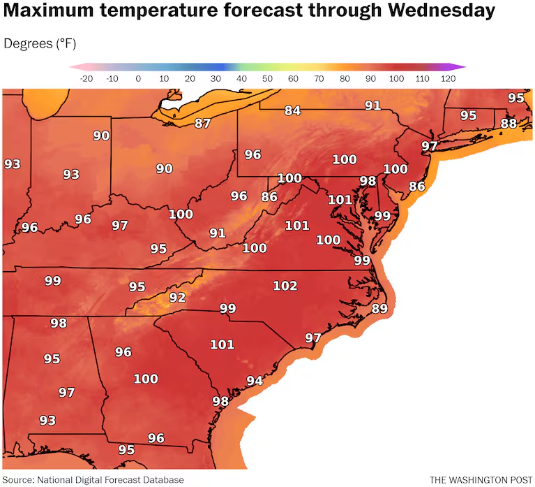
Philadelphia — Heat warning, maximum of 100
Hot, humid and hazy conditions rule. Heat indexes rise to 105 or higher Monday and Tuesday, with overnight lows not far from 80. An air quality alert is also in effect. Storms with Wednesday’s cold front could be strong.
- Monday: 98 high
- Tuesday: 100 high / 77 low
- Wednesday: 96 high / 80 low
New York City — Heat advisory, maximum of 96
Some rain in the area early Monday doesn’t do anything to quell the heat and may end up increasing humidity. Heat indexes rise to around 100 Monday and Wednesday, while rising nearer 105 on Tuesday. Storms are most likely late Wednesday.
- Monday: 95 high
- Tuesday: 96 high / 77 low
- Wednesday: 93 high / 80 low
Boston — Heat advisory, maximum of 94
Lots of sun Monday and Tuesday will send temperatures toward the mid-90s, even right near the water. Showers and storms become more likely by late Wednesday.
- Monday: 92 high
- Tuesday: 94 high / 74 low
- Wednesday: 92 high / 75 low
Other locations
Charlotte — No alerts, maximum of 99
Heat indexes around 100 to 105 are coupled with mostly sunny skies and perhaps a few isolated afternoon or evening storms.
- Monday: 99 high
- Tuesday: 97 high / 75 low
- Wednesday: 95 high / 77 low
Charleston, S.C. — Heat warning, maximum of 98
A combination of extreme humidity and very high temperatures push coastal zones in and around Charleston to the limit. The heat index may approach 115.
- Monday: 98 high
- Tuesday: 95 high / 79 low
- Wednesday: 95 high / 79 low
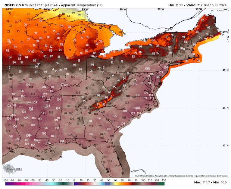
Heat index forecast for Tuesday afternoon shows widespread 100-110 feels-like temperatures. (weatherbell.com)
Roanoke, Va. — No alerts, maximum of 100
Sunny, hot conditions rule. Somewhat lower humidity than places farther to the east will help keep the heat index in check, but 100 is hot if it’s a dry heat or not.
- Monday: 98 high
- Tuesday: 100 high / 73 low
- Wednesday: 96 high / 75 low
Raleigh, N.C. — Heat advisory, maximum of 101
The city already set a record this month when it hit 106 on July 5. It’s not as hot this week, but multiple days with a heat index over 105 will take their toll.
- Monday: 101 high
- Tuesday: 99 high / 77 low
- Wednesday: 95 high / 77 low
Hartford, Conn. — Heat advisory, maximum of 95
Hartford has already seen 17 days reaching at least 90 so far this year, the second most on record to date. Several more are on the table this week. Heat indexes head to around 100.
- Monday: 95 high
- Tuesday: 95 high / 72 low
- Wednesday: 95 high / 74 low

How much warmer high temperatures are compared to normal for the forecast Tuesday. (weatherbell.com)
More on extreme heat
Use our tracker to see your city’s extreme heat risk.
How to stay safe: It’s better to prepare for extreme heat before you’re in it. Here’s our guide to bracing for a heat wave, tips for staying cool even if you don’t have air conditioning, and what to know about animal safety during extreme heat. Traveling during a heat wave isn’t ideal, but here’s what to do if you are.
Understanding the science: Sprawling zones of high pressure called heat domes fuel heat waves. Here’s how they work. You can also read more about the link between weather disasters and climate change, and take a look at what extreme heat does to the human body.
By Ian Livingston Ian Livingston is a forecaster/photographer and information lead for the Capital Weather Gang. By day, Ian is a defense and national security researcher at a D.C. think tank. Twitter
More:
Here are more “ETs” recorded from around the planet the last couple of days, their consequences, and some extreme temperature outlooks, as well as any extreme precipitation reports or outlooks:
Here is more new June 2024 climatology (See the rest of last month’s climatology on prior daily posts.):
Here is More Climate News from Monday:
(As usual, this will be a fluid post in which more information gets added during the day as it crosses my radar, crediting all who have put it on-line. Items will be archived on this site for posterity. In most instances click on the pictures of each tweet to see each article. The most noteworthy items will be listed first.)