The main purpose of this ongoing blog will be to track planetary extreme, or record temperatures related to climate change. Any reports I see of ETs will be listed below the main topic of the day. I’ll refer to extreme or record temperatures as ETs (not extraterrestrials).😜
Main Topic: Day 3 (An American Tragedy)-CAT5 Hurricane Milton Headed Towards Tampa
Dear Diary. As of noon today, Milton was upgraded to a CAT5 hurricane. The system will come very close to the Yucatan Peninsula then race towards the central Florida west coast, arriving sometime Wednesday night or Thursday. Very unfortunately, it looks like Milton will be the Katrina of our time, so for the next few days we will concentrate on it.
If you are thinking about an “October Surprise” as far as the election goes, this might be it. Liberals need to hammer home the fact that conservatives have been denying climate change from fossil fuel use for decades…just saying.
Milton is forecast to encounter some light shear after strengthening even more in the southern Gulf today, so the system is not pegged to come into Florida as a CAT5. Still…
Mirroring what we posted on Saturday and Sunday, here are the latest models in association with Milton. The GFS has been consistent with both the track and strength of the system for days:
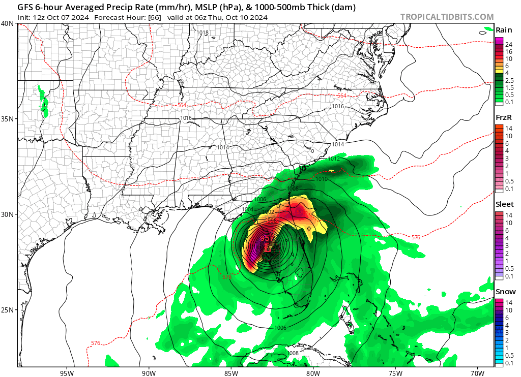
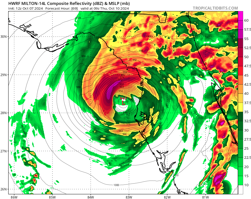
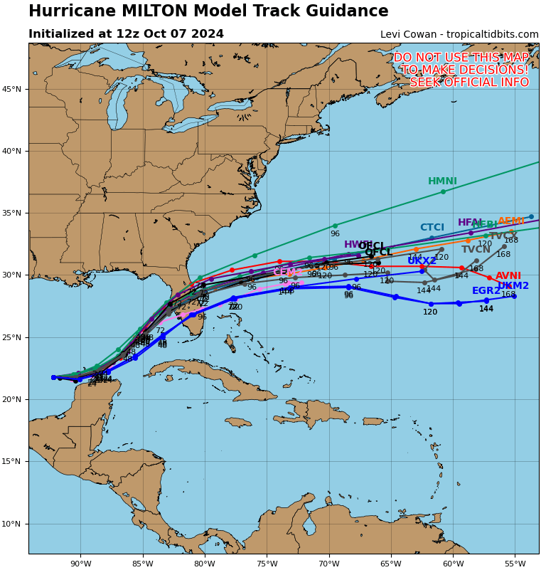
As far as Tampa goes, there is now only a little wiggle room for a better scenario than the worst case- a strong CAT4 coming into the northern part of the bay. Here is Dr. Jeff Master’s latest take on scenarios for that city, which literally could be wiped off the map given some of the guidance we are seeing today:
Best- and worst-case hurricane scenarios for Tampa Bay » Yale Climate Connections
Best- and worst-case hurricane scenarios for Tampa Bay
The most vulnerable metropolitan area in the U.S. to storm surge damage is Tampa/St. Petersburg.

by Jeff Masters
October 6, 2024
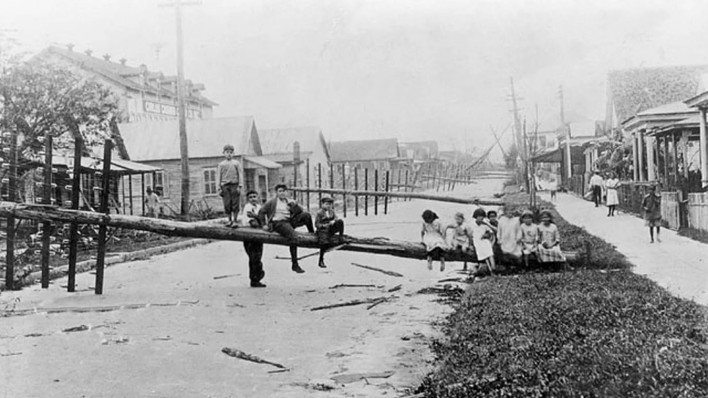
Kids playing on a downed telephone pole on 5th Avenue at 22nd Street in Ybor City after the 1921 Tampa Bay Hurricane. (image credit: tampapix.com)
The most vulnerable metropolitan area in the U.S. to storm surge damage is Tampa/St. Petersburg. That’s according to a 2015 report by Karen Clark & Company, Most Vulnerable US Cities to Storm Surge Flooding. Their 1-in-100-year storm (with a 1% chance of occurring in any given year) was a strong Category 4 hurricane with 150 mph (240 km/h) winds. Such a storm striking just north of Tampa Bay could be expected to cause $230 billion in damage (2024 USD) – just from the storm surge.
Tampa Bay doesn’t get hit very often by hurricanes, because the city faces the ocean to the west, and the prevailing east-to-west trade winds at that latitude make it uncommon for a storm to make a direct hit on the west coast of Florida from the ocean. This is fortunate, since the large expanse of shallow continental shelf waters offshore from Tampa Bay (less than 300 feet deep out to 90 miles offshore) is conducive for allowing large storm surges to build.
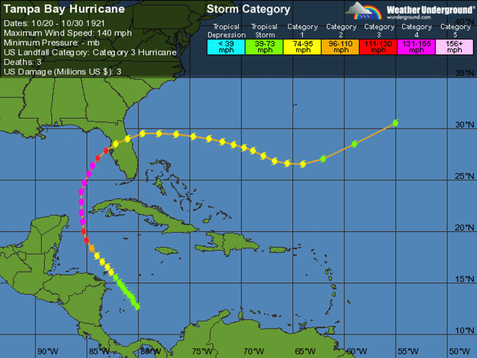
Figure 1. Track of the 1921 Tampa Bay Hurricane, the last major hurricane to hit the city. (Image credit: Weather Underground)
The last time Tampa suffered a direct hit by any hurricane was 1946, when a Category 1 storm came up through the bay. The Tampa Bay Hurricane of October 25, 1921 was the last major hurricane to make landfall in the Tampa Bay region. This low-end Category 3 storm with 115 mph (185 km/h) winds at landfall brought a storm tide of 10-11.5 feet (3-3.5 m), causing severe damage ($180 million 2024 dollars.) The only other major hurricane to hit the city occurred on September 25, 1848, when the Great Gale of 1848, the most violent hurricane in Tampa’s history, roared ashore as a Category 3 or 4 hurricane with 115-135 mph winds. A 15-foot (4.6 m) storm surge was observed in what is now downtown Tampa, and the peninsula where St. Petersburg lies, in Pinellas County, was inundated, making St. Petersburg an island. A large portion of the few human structures then in the area were destroyed.
When the 1921 hurricane hit Tampa Bay, about 160,000 residents lived in the four-county region, mostly in communities on high ground. Today there are over 3.5 million residents in the region, and that number is growing by about 50,000 people per year. Sea level is now about a foot higher than in 1921, so a storm surge from the same storm would do much more damage. A 2007 study by Tufts University, Florida and Climate Change, found that a 2.25-foot (0.7 m) increase in sea level–which many sea level rise scientists expect will happen by the end of the century – would put 152,000 people in Pinellas County (where St. Petersburg is located) under water at high tide.
Most of the population in the four-county Tampa Bay region lives along the coast in low-lying areas, about 50 percent of it at an elevation of less than 10 feet. More than 800,000 people live in evacuation zones for a Category 1 hurricane, and 2 million people live in evacuation zones for a Category 5 hurricane, according to the 2010 Statewide Regional Evacuation Study for the Tampa Bay Region. Given that only 46% of the people in the evacuation zones for a Category 1 hurricane evacuated when an evacuation order was given as 2004’s Category 4 Hurricane Charley threatened the region, the potential exists for high loss of life when the next major hurricane hits.
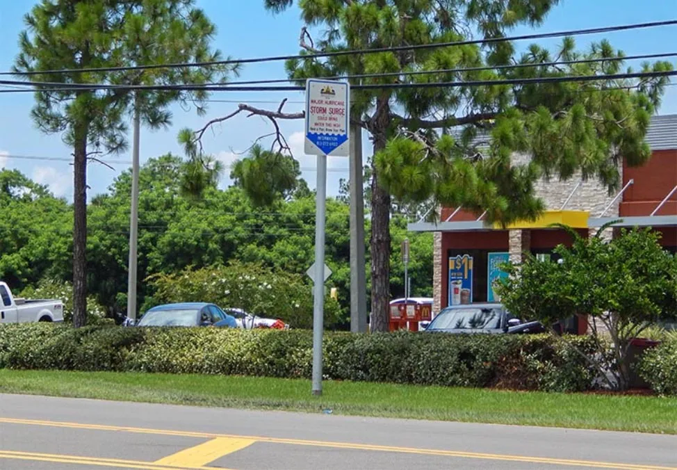
Figure 2. A sensible hurricane awareness effort: Hillsborough County, Florida got a $30,000 grant to post 30 of these signs around the Tampa Bay area to show how high a storm surge from a major hurricane might reach. This sign by a McDonalds at 19th Ave and Highway 41 is thirteen feet above ground level. Image credit: photonews247.com.
According to the second part of an excellent two-part series published in 2022 in the Tampa Bay Times, 11% of the properties in Tampa are at risk of flooding in a Cat 1 hurricane. In Pinellas County (where St. Petersburg is situated, and home to nearly one million people), this number is 20% – with nearly $30 billion in property. No Florida county has both more buildings and more value at risk, the article reported: “More than 700 essential properties like places of worship, gas stations, schools, government buildings and public utilities are at risk of Category 1 flooding. Category 2 storms expose 500 more. Almost 400 hotel properties, most along Pinellas’ famed beaches, are similarly vulnerable.”
Hurricane Helene
Tampa’s extreme vulnerability to hurricane storm surges was made painfully apparent last month. Despite its center passing 130 miles (205 km) to the west of Tampa Bay on Sep. 26, Hurricane Helene brought the bay its highest storm surge since record-keeping began in 1947, with water levels 5-8 feet above dry ground. According to local station fox13news.com, damage was heavy in the four-county Tampa Bay region: Pinellas County (home of St. Petersburg) had 28,000 damaged buildings, Pasco County had 9,900, and there were 8,600 in Manatee and Sarasota counties combined. Twelve storm-related deaths occurred in Pinellas County, two in Manatee County, and two in Hillsborough County.
Damages in Manatee and Sarasota County alone were estimated at $1.1 billion. Damage estimates for the other counties are not available yet, but since over four times as many buildings were damaged in Pinellas and Pasco Counties compared to Manatee and Sarasota Counties, we can expect several billions of dollars in additional damage, making Helene the most damaging hurricane on record for Tampa Bay.
Other estimates of Tampa Bay’s hurricane risk
In 2010, the Tampa Bay Regional Planning Council put out the Tampa Bay Catastrophic Plan, a scenario where a Category 5 “Hurricane Phoenix” hits downtown Tampa with 160 mph winds and a 26-foot storm surge. The study projected that the city would see about 2,000 deaths and nearly $250 billion in damage.
Video 1. A newscast I hope I never see the likes of: a frightening look at the potential effects of a catastrophic Category 5 hurricane making a direct landfall on the Tampa Bay metro area, as envisioned by the 2010 Tampa Bay Catastrophic Plan Hurricane Phoenix scenario.
In 2016, Dr. Peter Sousounis, a meteorologist for risk modeling company AIR Worldwide, told me in an email that their maximum loss-causing event for Tampa Bay was a Category 5 storm with sustained winds of 220 mph (355 km/h) that hits Manatee County with a central pressure of 887 mb. This nightmare storm generated $290 billion in insured losses (2024 USD) in a four-county region (Manatee, Pinellas, Pasco and Hillsborough counties) – a level of loss for those counties that had a 1-in-10,000-year recurrence interval. Since uninsured losses from a hurricane strike are usually roughly as much as the insured losses, the total damage from this storm might top $400 billion.
Tampa’s “Category 6” hurricane: a mind-boggling 830-mb storm with 233 mph winds
But perhaps the ultimate worst-case scenario for Tampa was outlined in a 2015 paper by Kerry Emanuel of MIT and Ning Lin of Princeton University, “Grey swan tropical cyclones” (press release here.) They found that an extreme Cat 5 hurricanes capable of delivering a storm surge of 26-36 feet (8-11 m) to Tampa had an extremely low or negligible probabilities in the climate of the late 20th Century, but are projected to happen as 1-in-5,000 to 1-in-150,000-year events in the late twenty-first century. We might need to invent a “Category 6” designation for the 1-in-150,000-year storm that came up in their simulations – a run of the HADGEM climate model that showed an unimaginably intense hurricane with a central pressure of 830 mb, top sustained winds of 233 mph (375 km/h), traveling parallel to the coast along just the right track to generate a titanic 36-foot (11 m) storm surge in Tampa Bay. Even accounting for the 15% reduction in winds that would occur due to friction over land, the winds from such a Category 6 hurricane would be like those of the EF5 tornado that leveled Joplin Missouri – except that EF4 to EF5 damage would be along a swath 22 miles wide, instead of a few hundred yards wide!
A July 2016 paper by Columbia University hurricane scientist Adam Sobel and colleagues in Science, Human influence on tropical cyclone intensity, stated that we should expect to see about a 2.2 mph (1 m/s) per decade increase in the winds of the strongest hurricanes, or about 19 mph by the year 2100. If we assume the 215 mph sustained winds of 2015’s Hurricane Patricia (off the Pacific coast of Mexico) as the current maximum potential intensity that a hurricane can reach, a 233-mph (375 km/h) hurricane by the end of the century is definitely a possibility.
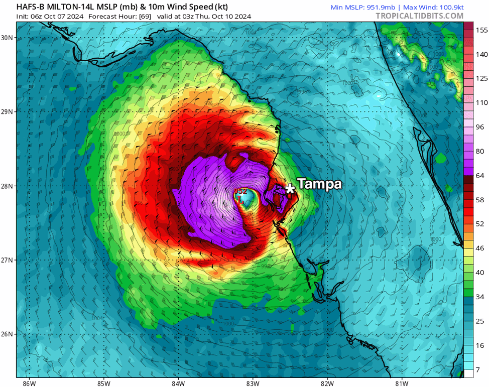
Figure 3. Predicted wind speed (colors) and sea level pressure (black lines) for Hurricane Milton at 11 p.m. EDT Wednesday, Oct. 10, from the 6Z Monday, Oct. 7, run of the HAFS-B model. The model predicted Milton would strike as a Cat 3 just north of Tampa Bay, a location that would maximize surge in the bay. (Image credit: Tropical Tidbits)
Current worst-case scenarios for Tampa Bay for Milton
Our five top hurricane-specific forecast models – the HWRF, HMON, HAFS-A, HAFS-B, and COAMPS-TC – have been painting some extremely ugly possible futures for Tampa Bay from Hurricane Milton. At least one run in recent days from all of these models have predicted Milton would achieve Cat 4 or Cat 5 strength on Tuesday or Wednesday. Many of the runs have shown a landfall just north of Tampa Bay, which would maximize the surge in the bay. However, many recent runs of these models have predicted that high wind shear and dry air would combine to disrupt Milton’s core before landfall, causing rapid weakening, with a potential Cat 1 or Cat 2 landfall resulting. Unfortunately, such a rapid weakening would allow the hurricane’s strongest winds to spread out over a larger area, resulting in a damaging surge characteristic of a Cat 3 hurricane affecting a larger portion of the coast. The most devastating scenario for Tampa Bay painted by any of the model runs from 6Z (2 a.m. EDT) Monday was from the new HAFS-B model, which showed Milton hitting as a large Cat 3 with 115 mph (185 km/h) winds just north of Tampa Bay (Fig. 3). Such a storm would likely generate a storm surge in the bay in excess of 10 feet, causing over $10 billion in damage. The HAFS-B model outperformed all the other models for 3-, 4-, and 5-day forecasts last year.

Figure 4. Predicted track and Saffir-Simpson category for Hurricane Milton from the 18Z Sunday, Oct. 6, run of the COAMPS-TC model. The model predicted Milton would make landfall about 80 miles south of Tampa (near Fort Myers, Florida), as a Cat 3 hurricane. (Image credit: U.S. Navy)
A current best-case scenario for Tampa Bay
A plausible best-case scenario for Tampa Bay was portrayed by the 18Z (2 p.m. EDT) Sunday, Oct. 6 run of the COAMPS-TC model (Fig. 4). The model depicted Milton making landfall about 80 miles south of Tampa Bay (near Fort Myers) as a low-end Cat 3. Such a track would spare Tampa Bay from significant wind and storm surge impacts. However, Tampa’s best-case scenario would be a nightmare scenario for southwestern Florida, with over $10 billion in damage likely.
Update: With the new 6Z Monday runs of the HWRF, HMON, HAFS-A, HAFS-B, COAMPS-TC, GFS, and European models, all painted variations of a dire scenario for Milton for Tampa Bay, showing a landfall just to the north of or over Tampa Bay. The only model showing a best-case scenario for them was the 0Z Monday run of the UKMET model, which depicted a landfall near Fort Myers, about 80 miles south of Tampa Bay.
Bottom line: prepare for the worst. My post, 30 great tools to determine your flood risk in the U.S., is a good place to go to evaluate your flood risk.

Jeff Masters
Jeff Masters, Ph.D., worked as a hurricane scientist with the NOAA Hurricane Hunters from 1986-1990. After a near-fatal flight into category 5 Hurricane Hugo, he left the Hurricane Hunters to pursue a… More by Jeff Masters
Dr. Jeff Master’s Best- and worst-case hurricane scenarios for Tampa Bay was first published on Yale Climate Connections, a program of the Yale School of the Environment, available at: http://yaleclimateconnections.org. This work is licensed under a Creative Commons Attribution-Noncommercial-No Derivative Works 2.5 license (CC BY-NC-ND 2.5).
Much More (Newest and most important items will be listed first. I’ll have many updates as Monday rolls along):
Here are more “ETs” recorded from around the planet the last couple of days, their consequences, and some extreme temperature outlooks, as well as any extreme precipitation reports:
Here is some more September 2024 climatology (Prior reports are listed on older daily diary blogs for each calendar day.):
Here is More Climate News from Monday:
(As usual, this will be a fluid post in which more information gets added during the day as it crosses my radar, crediting all who have put it on-line. Items will be archived on this site for posterity. In most instances click on the pictures of each tweet to see each article. The most noteworthy items will be listed first.)