Here is a new feature for this blog, which I will add daily. This is the latest inciteful Green News Report from my friends Desi Doyen and Brad Friedman at Progressive Voices. Hit ‘continue reading,’ listen, then hit return to see my daily topics:
Main Topic: Gulf of Mexico Waters Are Heating Up Twice as Fast as Global Oceans, With Huge Implications for Hurricane Risk.
Dear Diary. Some large basins of water are heating up faster than the worldwide average for global oceans due to carbon pollution but also because if ocean circulation and other factors. The one that I am physically closest to is the Gulf of Mexico is warming up twice as fast as the average of the Earth’s oceans. Why is this? Why is that very worrisome for residents on its shores?
To help answer these questions, here is a new post by Dr. Jeff Masters:
Something startling is happening in the Gulf of Mexico » Yale Climate Connections
Something startling is happening in the Gulf of Mexico
Its waters are heating up twice as fast as the global oceans, with huge implications for hurricane risk.

by Jeff Masters
May 13, 2026

Rapidly warming waters in the Gulf of Mexico could fuel more intense hurricanes.
In 2012, the temperature of the Gulf of Mexico began rising along a shocking upward trajectory.
Climate change is causing oceans worldwide to warm. But that year, summertime sea surface temperatures in the Gulf of Mexico began heating up at about twice the rate seen in the global oceans. The trend has continued into the 2020s, with sea surface temperatures hitting record highs in both 2024 and 2025. The shift has huge implications for the hurricanes that form in the Gulf – and the people who live along its shores and on the islands that dot its waters.
Hurricanes are heat engines that take heat energy out of the ocean and convert it to the kinetic energy of wind. The maximum intensity that a hurricane can reach increases by about 5-7% per degree Celsius of sea surface temperature increase. So the rise of about half a degree per decade in Gulf sea surface temperatures per decade since 2012 may be causing a 3% per decade increase in the winds of the strongest hurricanes. Because stronger winds cause more destruction, this equates to about a 30% increase in hurricane damage per decade for these strongest storms.

Figure 1. Departure of sea surface temperature from average in the Gulf of Mexico during the peak three months of hurricane season, August-September-October. The long-term trend from 1850-2025 is only 0.03°C per decade but has increased by a factor of 10, to 0.32°C per decade, over the past 30 years (1996-2025), and by a factor of a factor of 16 from 2012-2025. (Image credit: NOAA)
When a hurricane traverses a shallow area of warm ocean waters, its powerful winds churn up cold waters from the depths, cooling the surface and putting the brakes on the storm’s intensification. But when unusually warm ocean waters extend 100 meters or more below the surface, the hurricane’s winds simply stir up more warm water, in some cases allowing dangerous rapid intensification to occur. This phenomenon fueled Hurricane Helene’s furious winds as the storm bore down on Florida in 2024.
So why have sea surface temperatures been rising so rapidly in the Gulf of Mexico? Will the temperatures keep rising? And what does it all mean for hurricanes?

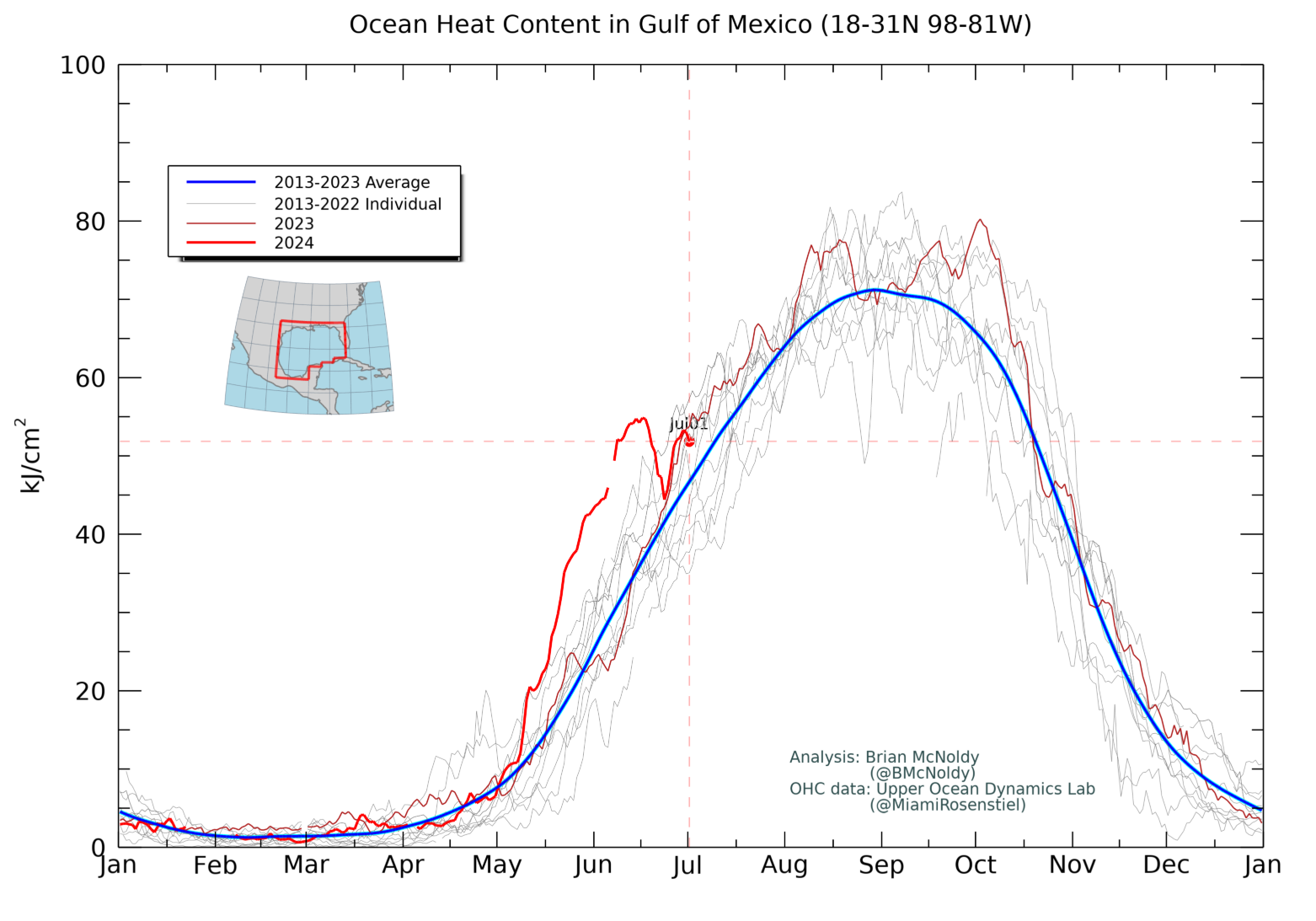
Figure 2. Ocean heat content in the Gulf of Mexico, Jan. 1, 2013-May 11, 2026. (Image credit: Brian McNoldy, University of Miami)
Global warming and ocean current changes are to blame
The cause of the Gulf’s warming trend is not just climate change, but also the behavior of a wide ribbon of water called the Loop Current.
This ocean current transports warm Caribbean water through the Yucatan Channel between Cuba and Mexico, northward into the Gulf of Mexico, in a loop southeastward just south of the Florida Keys – where it is called the Florida Current – and then just west of the westernmost Bahamas. There, the waters of the Loop Current flow northward along the U.S. coast and become the Gulf Stream.
With speeds of about 1.8 mph (0.8 m/s), the Loop Current is one of the fastest currents in the Atlantic Ocean. During summer and fall, its deep, warm waters can provide a huge energy source that fuels rapidly intensifying major hurricanes. Rapid intensification is dangerous because when storms strengthen quickly, they can take people by surprise, leaving little time for preparation or evacuation.
The Loop Current often bulges out in the northern Gulf of Mexico, where it sometimes sheds a clockwise-rotating ring of warm water that separates from the main current. This ring of warm water – called a Loop Current ring, Loop Current eddy, or warm core ring – slowly drifts west-southwestward toward Texas or Mexico at two to three miles per day.
The Loop Current pulsates in a quasi-regular fashion, shedding rings every six to 11 months. When a Loop Current eddy breaks off in the Gulf of Mexico at the height of hurricane season, it can provide a vast reservoir of energy to any hurricane that crosses over.
A 2024 paper, Loop Current Eddies as a Possible Cause of the Rapid Sea Level Rise in the Gulf of Mexico, found that in recent years, Loop Current eddies have been growing larger – in fact, their surface area increased by about 50% compared to previous decades. As a result, they’re transporting more warm water into the Gulf, raising sea surface temperatures and sea levels.
That explains the spike in temperatures. But why are the eddies getting larger?
A 2023 paper theorized that the huge clockwise-spinning ocean current system spanning most of the North Atlantic Ocean, called the North Atlantic subtropical gyre, had expanded, causing the Loop Current to transport more warm water into the Gulf of Mexico. The authors concluded that about 40% of this shift was from climate change and about 60% was from natural variability.

Figure 3. Ocean current speeds (cm/s, colors) at 0Z May 17, 2022, as analyzed by the Navy HYCOM model. Arrows show the direction of the current. The fastest currents were associated with the Loop Current, which was flowing northward from the Western Caribbean into the east-central Gulf of Mexico, before looping back to the southeast and flowing to the south of Florida. A warm eddy that broke off from the Loop Current in 2021 (which helped fuel the rapid intensification of Hurricane Ida on August 29, 2021) had drifted west to a position about 200 miles south of western Louisiana. (Image credit: Navy Research Lab)
They predicted that this effect would die down within the next decade or so, reducing the amount of warm water being transported into the Gulf of Mexico. If they’re right, the rate at which warm water is being delivered to the Gulf will likely decline within the next five or so years, making the Gulf’s rising temperature closer to the global average increase.
A climate regime shift after the 2015-16 Super El Niño?
Part of the dramatic increase in sea surface temperatures since 2016, though, may be from a “super-El Niño” event in 2015-16. Three “super-El Niño” events of approximately equal strength occurred in 1982-83, 1997-98, and 2015-16. According to a 2026 paper, Super El Niño events drive climate regime shifts with enhanced risks under global warming, these events were all responsible for multiple regional climate regime shifts, characterized by an abrupt and persistent transition between alternative stable states in the climate system. One such regime shift after the 2015-16 super El Niño may have been responsible for the abrupt warming of wintertime sea surface temperatures that occurred in the Gulf of Mexico beginning in 2016-17. Over the past 10 winters, Gulf sea surface temperatures have averaged 0.8 degree Celsius above normal; during the previous 10 winters, they were just 0.2 degree above normal. The authors speculated that this regime shift may have contributed to the remarkable number of rapidly intensifying hurricanes observed in the Gulf beginning in 2017.
It remains to be seen whether this year’s evolving El Niño – which could be on par with the three events above – might trigger its own regime shift in the Gulf.
What’s next for the Gulf of Mexico?
As of May 11, 2026, sea surface temperatures and ocean heat content in the Gulf are at near-record levels, with the sea surface temperatures tied with May 11, 2024, as the warmest on record for the date – over 1 degree Celsius above the 1991-2020 average. The Loop Current shed a ring in February, and it’s now in a regrowth phase, extending northward again. This mode favors the release of another Loop Current eddy during the peak of hurricane season, which would increase the odds of rapid intensification of storms in the Gulf.

Figure 4. Sea surface temperatures in the Gulf of Mexico from 1991 to 2026. As of May 11, 2026, sea surface temperatures were tied with May 11, 2024, as the warmest on record for the date. (Image credit: Kim Wood, University of Arizona)
Recent seasonal forecasts from NOAA’s CFS model predict that Gulf sea surface temperatures during the peak of hurricane season will fall short of the records set in 2023-2025.
Longer term, the risk of rapid intensification of hurricanes is rising.
The 2015 paper, Potential impact of climate change on the Intra-Americas Sea: Part-1. A dynamic downscaling of the CMIP5 model projections, warned: “the enhanced warming along the northeastern shelf of the Gulf of Mexico could greatly increase the chance for rapid intensification of hurricanes making landfall across the northeastern Gulf Coast in the 21st century.”
Only 10 landfalling continental U.S. storms since 1950 have rapidly intensified by at least 40 mph (64 km/h) in the 24 hours before landfall. Five of those storms occurred in the past nine years.
But so far, there isn’t a clear relationship between the recent spike in sea surface temperatures in the Gulf of Mexico and the total number of rapidly intensifying hurricanes. From 2012 to 2025, 11 of the 29 hurricanes observed in the Gulf underwent rapid intensification. That compares with 14 out of 27 hurricanes during the previous 14-year period, including five during the extraordinarily active 2005 season, when sea surface temperatures were unusually high in the Gulf.
What about the even longer term? According to the latest generation of Intergovernmental Panel on Climate Change models, a moderate global warming scenario would cause a 0.5-1.5 degrees Celsius (0.9-2.7°F) warming of the Gulf during the August-November portion of hurricane season for the period 2036-2065, compared to the historical period 1982-2011. Under an extreme global warming scenario, this warming is predicted to be 1.5-3 degrees Celsius (2.7-5.4°F).
But NOAA data for the past 10 years shows that the Gulf has already warmed by 0.8 degree Celsius (1.4°F), so the observed warming is decades ahead of where it was expected to be under a moderate global warming scenario. This suggests that sea surface temperatures in the Gulf may be following the extreme global warming scenario.
However, these models are too crude to properly resolve the details of the ocean circulation in the Gulf of Mexico. A 2015 paper, Potential impact of climate change on the Intra-Americas Sea: Part-1. A dynamic downscaling of the CMIP5 model projections, used a detailed NOAA Geophysical Fluid Dynamics Laboratory model to come up with a more sophisticated forecast for the last decade of the century.
Under a moderate global warming scenario, that model predicted that the Atlantic Meridional Overturning Circulation would slow by about 20-25%, causing the Loop Current eddies in the Gulf of Mexico to become less active.
As a result, the smaller-scale Loop Current eddies would transport less warm water from the Caribbean into the Gulf, resulting in less heat being transported into the Gulf.
But there would also be less heat being transported out of the Gulf, resulting in the shallow surface waters near the coast from Louisiana to western Florida warming more than 2 degrees Celsius (3.6°F) compared to today (see Bluesky post below).
Such an increase would significantly increase hurricane winds, rain, and storm surge. Since the maximum intensity that a hurricane can reach increases about 5-7% per degree Celsius of sea surface temperature increase, a 2°C warming of water temperatures could cause a 10-14% increase in the winds of extreme hurricanes. This equates to over a doubling in their potential damage.
Other posts in this series
- Climate change is supercharging hurricane rainfall, contributing to deadly floods (2026)
- How strong can a hurricane get in a warming world? (2026)
- Global warming is making the strongest hurricanes stronger (2026)
- Will climate change bring more major hurricane landfalls to the U.S.? (2026)
- The emerging danger of post-hurricane heat waves (2026)
- The future of Atlantic hurricane tracks (2026)
- Climate change strengthened Hurricane Melissa, making the storm’s winds stronger and the damage worse (2025)
- Climate change behind 36% of damage inflicted by Typhoon Ragasa in China (2025)
- Climate change brings more rapidly intensifying hurricanes; NOAA cuts makes forecasting them harder (2025)
- Human-caused ocean warming intensified recent hurricanes, including all 11 Atlantic hurricanes in 2024 (2024)
- Without climate change, Hurricane Milton would have hit as a Cat 2, not a Cat 3 (2024)
- Four ways climate change likely made Hurricane Helene worse (2024)
- Does the Saffir-Simpson Scale for hurricanes need a Category 6? (2024)
- Hotter ocean temperatures from global warming likely increased Idalia’s destructive power by at least 40-50% (2023)
- How sea level rise contributes to billions in extra damage during hurricanes (2022)
- Warming climate makes extreme hurricane rains more likely for Puerto Rico (2022)
- Why are there so many Atlantic named storms? Five possible explanations. (2021)
Bob Henson contributed to this post.
Editors’ note: If you are unable to see the Disqus comments section under this post, you likely need to accept tracking cookies. A box titled Manage Consent should appear in the bottom right corner of Yale Climate Connections pages. If you click accept, you should be able to see the comments. If you do not see the Manage Consent box, see if there is a white tab in the bottom right corner, and click it to make the box appear. You also can try opening the site in a new window. If you’re still stuck, please reach out to our team.

Jeff Masters
Jeff Masters, Ph.D., worked as a hurricane scientist with the NOAA Hurricane Hunters from 1986-1990. After a near-fatal flight into category 5 Hurricane Hugo, he left the Hurricane Hunters to pursue a… More by Jeff Masters
Dr. Jeff Master’s “Something startling is happening in the Gulf of Mexico” was first published on Yale Climate Connections, a program of the Yale School of the Environment, available at: http://yaleclimateconnections.org. This work is licensed under a Creative Commons Attribution-Noncommercial-No Derivative Works 2.5 license (CC BY-NC-ND 2.5).
Here are some “ETs” recorded from around the U.S. the last couple of days, their consequences, and some extreme temperature outlooks, as well as any extreme precipitation reports:
Here is More Climate News from Thursday:
(As usual, this will be a fluid post in which more information gets added during the day as it crosses my radar, crediting all who have put it on-line. Items will be archived on this site for posterity. In most instances click on the pictures of each tweet to see each article. The most noteworthy items will be listed first.)