The main purpose of this ongoing blog will be to track planetary extreme, or record temperatures related to climate change. Any reports I see of ETs will be listed below the main topic of the day. I’ll refer to extreme or record temperatures as ETs (not extraterrestrials).😉
Main Topic: Historic Cold Wave Elliot to Chill the U.S. In Wake of a Bomb Cyclone
Dear Diary. Using my criteria for cold outbreaks, it is now a slam dunk that we will see a CAT4 if not borderline CAT5 cold wave for this week of Christmas named Elliot. If there is a named winter storm by the Weather Channel that ushers in a significant cold wave, the cold wave will have the same name as that winter storm. You can read my criteria for categorizing and naming food outbreaks here
This is a highly dangerous situation with the potential to kill just as many if not more people than a historic CAT4 heatwave since a “bomb cyclone” blizzard will accompany the cold wave system.
On Tuesday the National Weather Service has a multitude of winter storm watches and wind chill watched out for Cold Wave Elliot:

(Turquoise green colors, such as those in Tennessee, represent wind chill watches while off blue colors, such as those in Iowa, represent winter storm watches. Grey colors, such as those across South Dakota, represent wind chill warnings. For others, see: National Weather Service)
As far as climate change goes, at +1.2°C above preindustrial average global temperatures as of 2022, we can still expect extreme deadly cold outbreaks in mid latitude areas. These are becoming rarer as noted by the absence of below 20° mins at my hometown of Atlanta, for example. This streak will be over by Thursday due to Cold Wave Elliot:
Number of Consecutive Days Min Temperature >= 20 for Atlanta Area, GA (ThreadEx)
| Rank | Run Length | Ending Date |
|---|---|---|
| 1 | 1796 | 2022-12-19 |
| 2 | 1076 | 1923-02-17 |
| 3 | 1033 | 1950-11-23 |
| 4 | 726 | 1914-02-07 |
| 5 | 705 | 1983-12-23 |
| 6 | 704 | 1882-12-06 |
| 7 | 693 | 2014-01-05 |
| 8 | 687 | 2017-01-07 |
| 9 | 686 | 1953-12-16 |
| 10 | 682 | 2006-12-07 |
| Period of record: 1878-10-04 to 2022-12-19 |
Source: xmACIS2 (rcc-acis.org)
The coldest readings for the bulk of the nation should be occurring on Christmas Eve morning:

Here are many more up to date details on this situation from the Washington Post:
Winter storm, blizzards to disrupt holiday travel this week across U.S. – The Washington Post
Fierce ‘bomb cyclone’ to disrupt holiday travel, unleash Arctic outbreak
The storm could bring blizzard conditions, extreme wind chills and travel headache for large parts of the Lower 48 states

December 20, 2022 at 10:22 a.m. EST

American model shows storm on Thursday night sweeping toward the Great Lakes. Blue-colored area indicates simulated snow; green shades indicate rain. (WeatherBell)
A massive storm system is set to snarl holiday travel and bring an onslaught of wintry weather to millions across the Plains, Great Lakes, Ohio Valley, Northeast and even interior Mid-Atlantic. The developing cyclone will deliver heavy snow and blizzard conditions to some and downpours to others between Wednesday and Friday night, all coming at a time of year when more than 110 million Americans are expected to take to the roads and air.
The potential exists for serious travel disruptions at major airport hubs in the Midwest and Great Lakes, including Chicago’s O’Hare International, where heavy snow and howling winds are expected — with the worst conditions Thursday into Friday.
Travel could “become extremely dangerous and life-threatening, particularly in light of the bitterly cold temperatures during the height of the storm,” wrote the National Weather Service office serving Chicago.
4 things to do now to prepare yourself and your home for extreme cold
Nearly 50 million Americans are under winter storm warnings, watches and advisories, a number of whom could find themselves blanketed by blizzard warnings before long. The anticipated storm system will explosively strengthen, at a rate sufficient to qualify it as a “bomb cyclone” — which is the most intense breed of mid-latitude storms.
“In summary, this is still looking to develop as a high end, life-threatening event,” wrote the Weather Service office serving Minneapolis.
The Weather Service office serving Buffalo called it a “once in a generation” storm system.
Airports all across the eastern U.S. could suffer cascading delays thanks to strong winds surrounding the system, which will sprawl close to 1,000 miles across. That could lead to impacts far and wide from Minneapolis and Milwaukee to Boston and Washington D.C. The strong winds could lead to power outages in locations experiencing dangerously low temperatures.
The storm will drag a historically cold December air mass — sourced from Siberia — over much of the Lower 48 between late Wednesday and late Friday sending temperatures plunging some 30 to 50 degrees below average. Readings in the teens could slosh all the way to the Gulf of Mexico, with a dangerous flash freeze turning wet roadways into a sheet of ice in some areas.
More than 30 million people are under wind chill alerts from the Rockies to the nation’s midsection. Projected wind chills on Friday morning include: 2 degrees in Houston; minus-7 in Dallas; minus-14 in Memphis; minus-32 in Kansas City, Mo.; and minus-45 in Sioux Falls, S.D.
“Dangerously cold wind chills, as low as 50 below zero” are expected in the Dakotas, wrote the National Weather Service. “Stranded motorists will face the threat of frostbite, hypothermia and even life-threatening exposure.”
The frigid air will bleed all the way to the Eastern Seaboard on Friday, setting the stage for the coldest Christmas since 1989 in many spots.
Dangerous Central U.S. blizzard likely
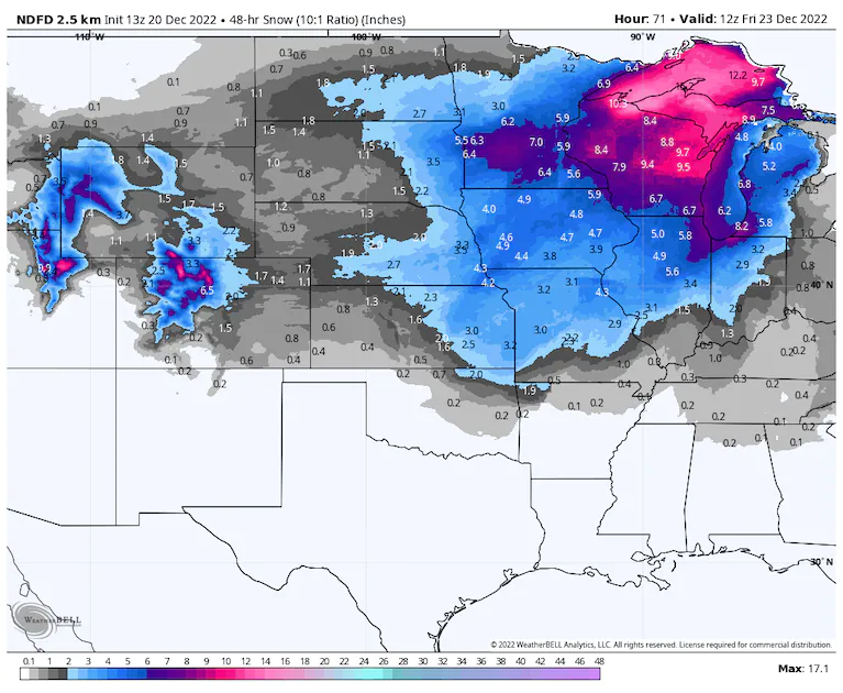
The National Weather Service’s snowfall forecast through Friday morning. Additional snow is probable after this time. (WeatherBell) (WeatherBell)
On Tuesday morning, a weather disturbance was draped over British Columbia, Alberta and Saskatchewan. It will intensify and consolidate into a bowling ball-shaped zone of low pressure at high altitudes, which will dive south over the Northern Plains, Corn Belt and Missouri Valley between Wednesday night and Friday. That will help brew a potent zone of low pressure nearer the ground that will swiftly strengthen, becoming a “bomb cyclone.”
The cyclone will first form over the High Plains of Colorado, Oklahoma and New Mexico on Wednesday night, making it to Memphis by noontime Thursday before beginning rapid intensification. By Friday morning, it will be near the Ohio River in northern Kentucky. That’s when it will dramatically intensify en route to Canada via the Great Lakes.
On the western side of the storm, moisture wrapping around the low and falling into cold air will deposit a swath of heavy snow, with jackpot totals possible exceeding 12 inches. It’s unclear where the maximum will fall, but it’s looking like Wisconsin and the Upper Peninsula of Michigan could be in the double digits for totals. A broad 6 to 10 inches is likely along the shores of Lake Michigan, including in Chicago, with a widespread 3 to 6 across most of the remainder of the Upper Midwest, Corn Belt and eastern Northern Plains.
Across much of the Great Lakes, the heaviest snowfall and worst conditions are expected between late Thursday afternoon and Friday night. Conditions could gradually improve on Saturday, although winds could still blow the fallen snow around, reducing visibility.
Snow will break out over the central Plains on Wednesday night into Thursday; as the system strengthens, the snow will become more intense and expansive in overage into Thursday afternoon, at which point it will be snowing moderately to heavily in Chicago and perhaps all the way down to Nashville.
Around this time, winds will pick up markedly, with widespread gusts of 35 to 50 mph common. That will lead to blizzard or near-blizzard conditions across most of the North central U.S. and western Great Lakes as dangerously-cold air pours into the region behind the storm’s cold front.
Even after the main slug of moisture passes into early Friday, wraparound moisture in the “comma head” of the cyclone will keep light to moderate snows going over Lake Michigan, and especially the eastern lakeshore.
The snow will eventually pivot into the Midwest and northern Ohio Valley before working into the Northeast as rain at first, since temperatures there will be warmer. However, in western Pennsylvania and New York, the rain should change to wind-whipped snow before ending, causing hazardous conditions on Friday and Friday night. Even locations farther east, toward the Interstate 95 corridor could see rain change to a very brief period of snow as the storm’s Arctic front comes through Friday. With rapidly falling temperatures, that could lead to slick roads.
Although the storm will lift into Canada by Christmas Eve, strong winds circulating around it will generate areas of heavy lake-effect snow on the shores downwind of the Great Lakes into Christmas Day — including around Buffalo
Interior Mid-Atlantic wintry weather on Thursday

A high-resolution model simulation of rain working up the Appalachians into a subfreezing environment Thursday, resulting in snow and freezing rain initially for some. (WeatherBell) (WeatherBell)
Outside of the main blizzard impact zone, a second area of concerning winter weather could come to manifest on Thursday. That will occur ahead of the main low pressure system as moisture rides up the Appalachians on Thursday. Subfreezing air entrenched in the mountains will take a little while to scour out, so initial precipitation will come down as snow and eventually freezing rain.
Winter storm watches are in effect in the Alleghenies of western Maryland, eastern West Virginia and adjacent western Virginia. That’s where 4 to 6 inches of snow, along with up to a quarter of an inch of ice, are likely. That could impact travel on Interstates 68 and 81 Thursday morning through the day.
Why flight delays could abound

The American GFS model simulates widespread windy conditions which could cause issues for flights. (WeatherBell) (WeatherBell)
The sheer size of this storm, which will stretch more than 1,000 miles across, is impressive in and of itself. Juxtaposed against a strong Arctic high pressure system to the west, however, the resulting contrast will be noteworthy. That extreme change in air pressure with distance will make for strong winds essentially over the eastern half of the Lower 48 on Thursday and into Friday. Gusts of 40 mph will be common, with some areas — especially near the Great Lakes — seeing gusts over 50 mph. Tree damage and power outages are probable in areas where it will be dangerously cold.
Where strong crosswinds intersect runways at perpendicular angles, flight delays will be frequent. For flights that take off, turbulence will make for an uncomfortable ride. This is especially true late Thursday into Friday.
A flash freeze

The American GFS model simulates temperatures plummeting Wednesday into Thursday. (WeatherBell) (WeatherBell)
Meanwhile, bitter-cold temperatures are already pooling over the northern Plains, heralding an even more bone-chilling air mass set to crash south over the U.S. in the next 24 to 48 hours. Temperatures could drop as much as 40 degrees or more in spots, plummeting to levels rivaling the cold air outbreak of 1989.
In the Texas Panhandle, this front will be a true “Blue Norther.” Readings will fall from the mid to upper 40s to the single digits in a matter of 5 or 6 hours on Wednesday night.
Houston will go from the mid to upper 60s on Thursday afternoon to the lower 20s by Friday morning with wind chills in the single digits.
Thereafter, the flash freeze front will reach the East Coast, with highs in the 40s and 50s on Friday replaced by lows in the teens by nightfall. Some models even suggest a 30 degree temperature drop in spots in 3 hours, which would challenge record temperature swings along the Interstate 95 corridor. Any roads in areas that are wet from rain or rain changing to snow could turn icy.
Major storm to soak D.C. area before a frigid Christmas weekend
How cold it will get

The American GFS model simulate temperature anomalies; readings 40 degrees or more below average are expected. (WeatherBell) (WeatherBell)
After the coldest air invades, it should stick around for 48 to 72 hours. The biting chill will blast into Denver Wednesday night, dropping temperatures from 40 degrees to zero in just a matter of hours. By Thursday morning, it will be near minus-10 with wind chills around minus-30. St. Louis, which will see highs in the mid-30s on Thursday along with some snow, will fall to minus-4 degrees on Thursday night. By Friday, highs will hover around 6 degrees, with lows around zero. Teens are likely for highs on Saturday.
Chicago will be in the single digits from Thursday night through Saturday. Kansas City will dip to minus-8 on Thursday night, and highs probably won’t make it above 4 or 5 degrees on Friday.
Lows in the minus-20s and minus-30s will be common across the Dakotas and Montana, and some places won’t make it above minus-10 degrees for several days in a row. Wind chills will range between minus-40 and minus-55 degrees.
Particularly impressive with this episode is how far south the cold air will blast. Virtually everyone along the Gulf Coast from Galveston to Tampa, including in New Orleans, Gulfport, Miss. and Mobile, Ala., will see lows around freezing on Friday night. That will result in “Arctic sea smoke” over the Gulf, or a rare type of fog resembling steam that forms when cold air blows over warmer water.
Toward the East Coast, temperatures will be 10 to 25 degrees below normal both Christmas Eve and Christmas Day. From Washington to Boston, highs should remain below freezing with lows in the teens.
Much of Florida, except for the far southern portion, will dip into the 30s or lower on Saturday night.
Here are some “ET’s” recorded from around the planet the last couple of days, their consequences, and some extreme temperature outlooks, as well as some extreme precipitation reports:
Here is more climate and weather news from Tuesday:
(As usual, this will be a fluid post in which more information gets added during the day as it crosses my radar, crediting all who have put it on-line. Items will be archived on this site for posterity. In most instances click on the pictures of each tweet to see each article. The most noteworthy items will be listed first.)
If you like these posts and my work please contribute via the PayPal widget, which has recently been added to this site. Thanks in advance for any support.)
Guy Walton… “The Climate Guy”
One thought on “Extreme Temperature Diary- Tuesday December 20th, 2022/Main Topic: Historic Cold Wave Elliot to Chill the U.S. In Wake of a Bomb Cyclone”