Friday September 14th… Dear Diary. The main purpose of this ongoing post will be to track United States extreme or record temperatures related to climate change. Any reports I see of ETs will be listed below the main topic of the day. I’ll refer to extreme or record temperatures as ETs (not extraterrestrials)😊. Here is today’s main climate change related topic:
Tracking Florence Day Six
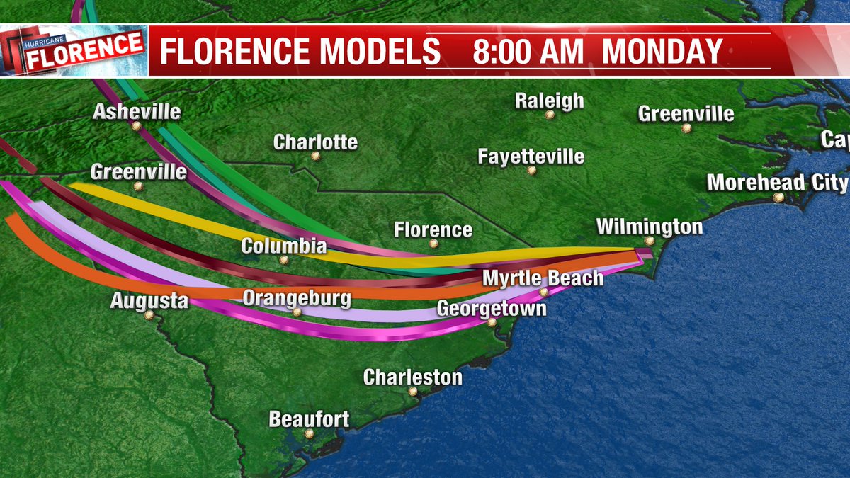
Today it’s time to start verifying forecasts over the prior five days going through today, Friday, in association with Florence. Of course, Florence won’t leave the Carolinas through Sunday, so we won’t be able to verify rainfall forecasts and exact track after landfall until early next week. What did us forecasters get right, and what went wrong?
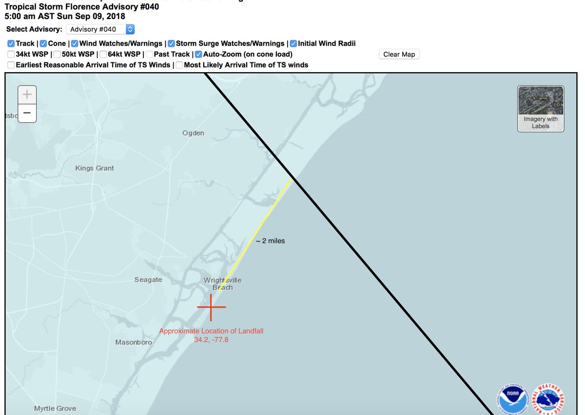
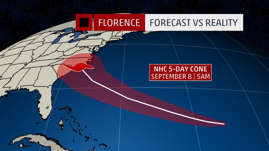
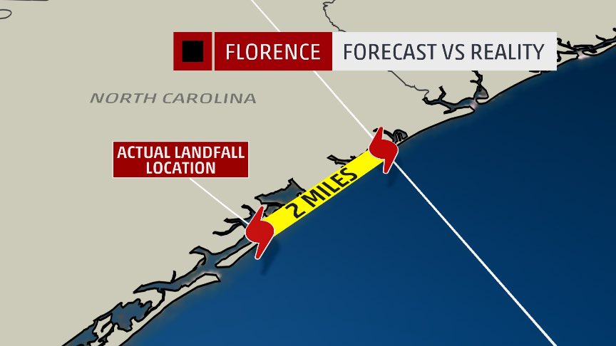
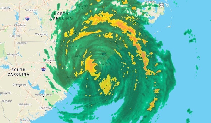
To start yours truly and many others were able to pinpoint a U.S. landfall near Wilmington many days out. Unfortunately most of us are only as good as computer models since forecasting has become a “lost art.” Forecasters mainly used weather pattern recognition to judge any rudimentary models prior to 1990. We have a new wrinkle, though, in this day and age of climate change. Traditional weather patterns prior to the turn of the 21st century are becoming unrecognizable due to climate change. Fortunately today’s models were able to successfully predict The 500 millibar pattern that I saw happening across North America at the time of Florence’s landfall is jaw-droppingly warm for mid- September. Anyway, here is a great graphic showing where old Florence made its landfall:
NEW: #Hurricane #Florence has made landfall near Wrightsville Beach, North Carolina at 7:15 AM EDT (1115 UTC) with estimated maximum winds of 90 mph (150 km/h), and a minimum central pressure estimate of 958 mb (28.29"). https://t.co/tW4KeGdBFb pic.twitter.com/vzpe6MjTf9
— National Hurricane Center (@NHC_Atlantic) September 14, 2018

Next time you complain about your local meteorologist blowing the forecast, remember this


This is what I have been calling Phase B of #hurricaneflorence …the slow movement and stall = major flooding, falling trees, power outages for days…I think many underestimated Phase B in #harvey. This is why overemphasis on Category so flawed…

I’m sure that there will be many an article calling for revisions to the Saffir-Simpson hurricane scale after this season.
Friday, as expected, will be the worst day for wind and storm surge damage so I will add many reports of this to today’s post. Flooding just from heavy rainfall is becoming horrific as well. Here are some of the many reports that I have seen today:
(As usual, this will be a fluid post in which more information gets added during the day as it crosses my radar, crediting all who have put it on-line. Older items are at the end of this list, which will be archived on this site.)

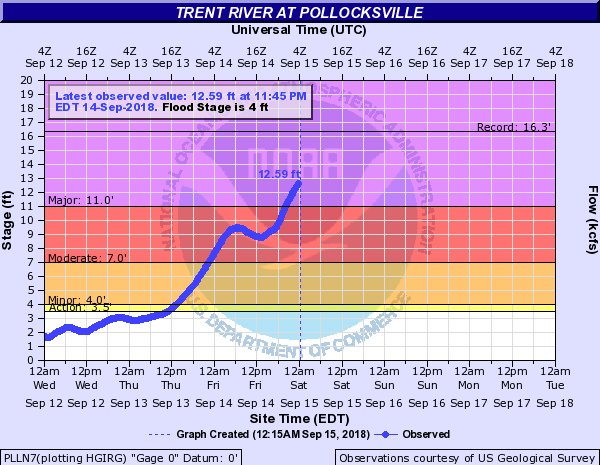
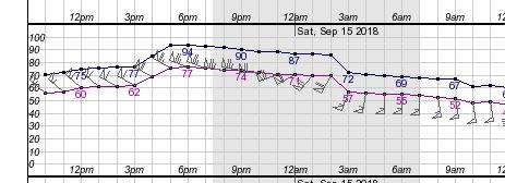
This graph captures how bad flooding is right now. The Trent River at Pollocksville will approach Floyd like or record levels. Graph: https://water.weather.gov/ahps2/hydrograph.php?wfo=mhx&gage=plln7 … #Florence #ncwx
Very dangerous #flood situation b/w #MoreheadCity & #Jacksonville, #NC as training rainbands east of #Florence are associated with 1-2" per hour rainfall rates continue to add to 10-25" rainfall totals so far.
Dangerous flooding is ongoing & will continue as bands slowly move. pic.twitter.com/vrYYrDGByB
— Philippe Papin (@pppapin) September 15, 2018
Flash flood warnings slowly expanding farther inland, but continuing near coast as we also head toward midnight high tide to maximize storm surge flooding at beach, in Pamlico Sound, and up rivers, like in New Bern also under Flash Flood Emergency. @NWSMoreheadCity #Florence pic.twitter.com/OeeY12Up4T
— Dr. Rick Knabb (@DrRickKnabb) September 15, 2018
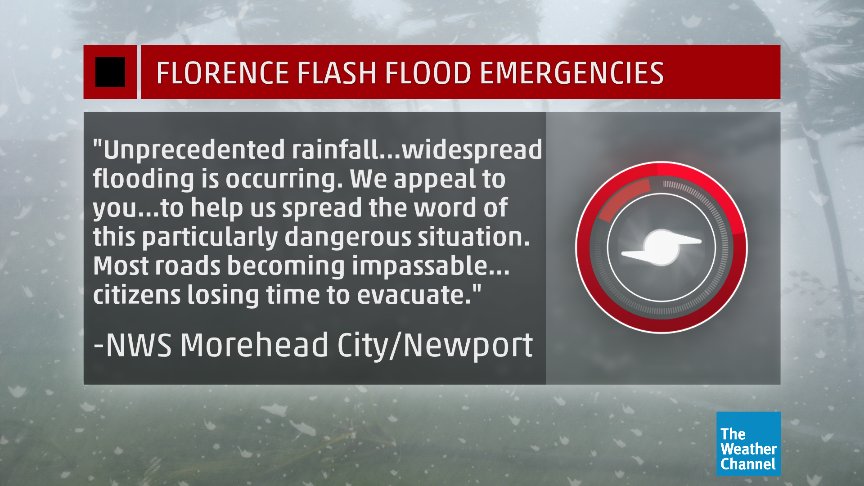
There is a FLASH FLOOD EMERGENCY for Carteret/Jones/Craven and Pamlico Counties until 9am. Widepsread flooding is occurring. Please help us spread word of this dangerous situation. Citizens are losing time to evacuate before the flood water become too high. @NCEmergency #Florence

PLEASE SHARE. Another look at the plea from @NWSMoreheadCity for help spreading the word to the public about the *life-threatening* flash flooding. Keep in mind NIGHT is falling & another HIGH TIDE is coming. #Florence #NCwx

Here's a look at the sunset over #TropicalStormFlorence, captured by #GOESEast. The storm is expected to move inland across eastern South Carolina tonight and Saturday before turning north toward the western Carolinas early next week. Latest: https://t.co/ROE9PMfPdt pic.twitter.com/aLLEcUwCg0
— NOAA Satellites (@NOAASatellites) September 15, 2018

More than 7,000 #ServiceMembers, @USNationalGuard and #ActiveDuty, are standing by to assist as #HurricaneFlorence hits the #EastCoast.
Read more: https://go.usa.gov/xPYuM

Large, slow-moving #Florence will be both a coastal and inland storm for days. Storm surge will continue for multiple noon/midnight high tide cycles in NC, soon SC. Most of eastern/central NC under flash flood warnings, slowly expanding inland in both NC and SC, life-threatening. pic.twitter.com/5BQlZolpl8
— Dr. Rick Knabb (@DrRickKnabb) September 14, 2018
The first fatalities of Florence have been confirmed

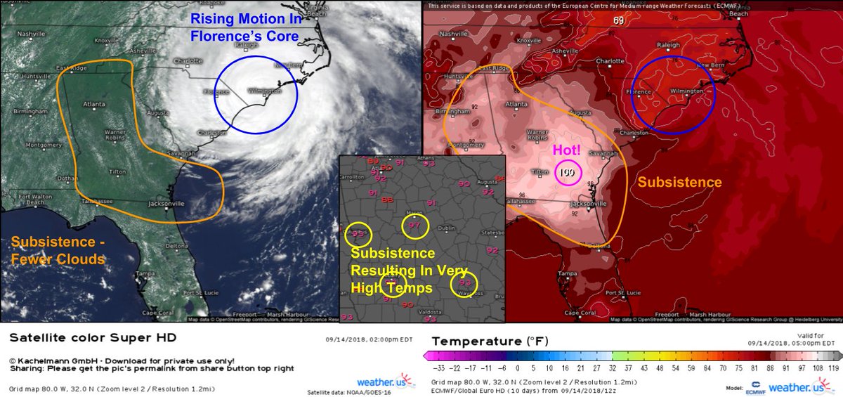
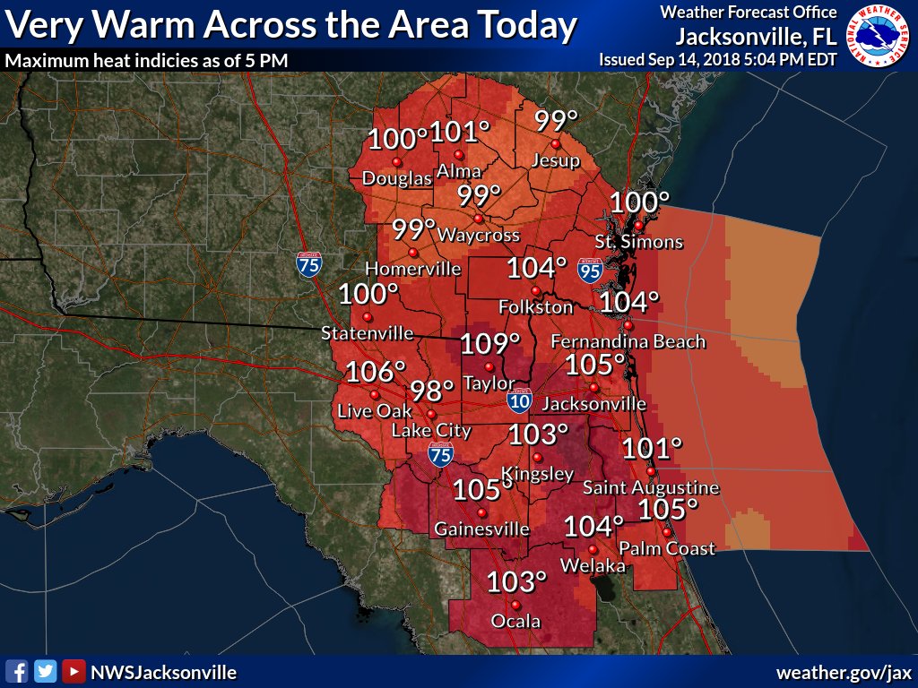
Interesting note on #GOESEast imagery/current temp obs/ECWMF forecast data this afternoon. Subsistence (sinking air) from #Florence is causing very warm temps in the mid to upper 90’s across S #GAwx and N #FLwx. Possibility for record highs! Watch obs: https://weather.us/observations/georgia/temperature-f/20180914-1800z.html …

“Warning of what has already arrived’: Florence is a climate change triple threat” | My latest op-Ed in The @Guardian:
https://www.theguardian.com/commentisfree/2018/sep/14/florence-climate-change-triple-threat
 Bob HensonVerified account @bhensonweather
Key point from the article: Beaufort, NC, had its highest water level on record early today–but without sea level rise since the 1950s, that record would not have occurred.
I can now add "hurricane moving southwest along the North Carolina coast" to the list of weather phenomena I thought I'd never see. pic.twitter.com/19mlanF9gR
— Tomer Burg (@burgwx) September 14, 2018
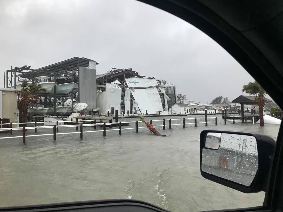
The moment the power flickered out in New Bern as Florence continues to send storm surge inland pic.twitter.com/7gcj24yMyG
— Brian L Kahn (@blkahn) September 14, 2018

#MyrtleBeach has had it pretty easy so far but thats about to change quickly this afternoon as #Florence heads right over you. Max wind gusts predicted in the 90-100 mph range from 5pm to midnight.

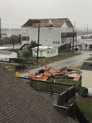
Fort Macon at Atlantic Beach has wind gusts over 100 MPH. This is roof damage a couple of miles from Ft Macon. #Florence #WRAL.
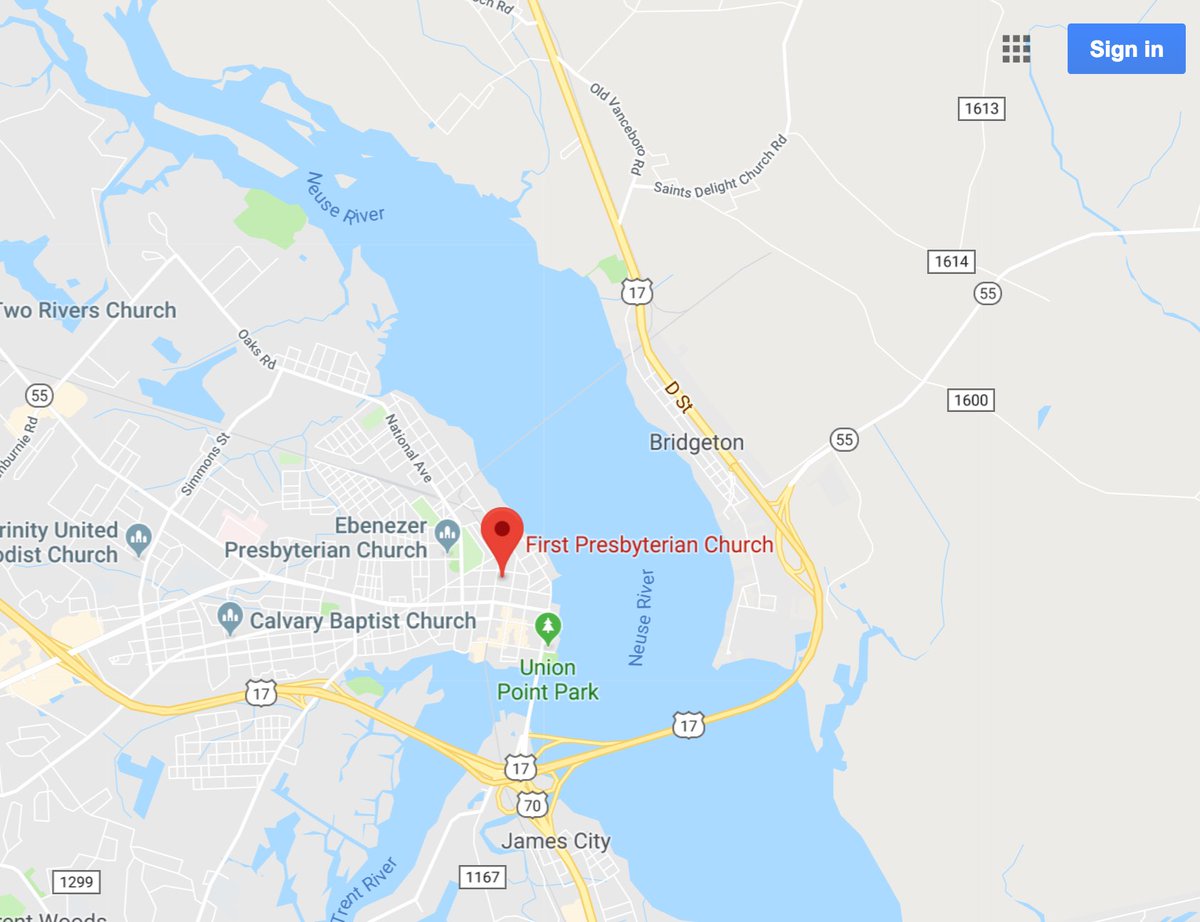
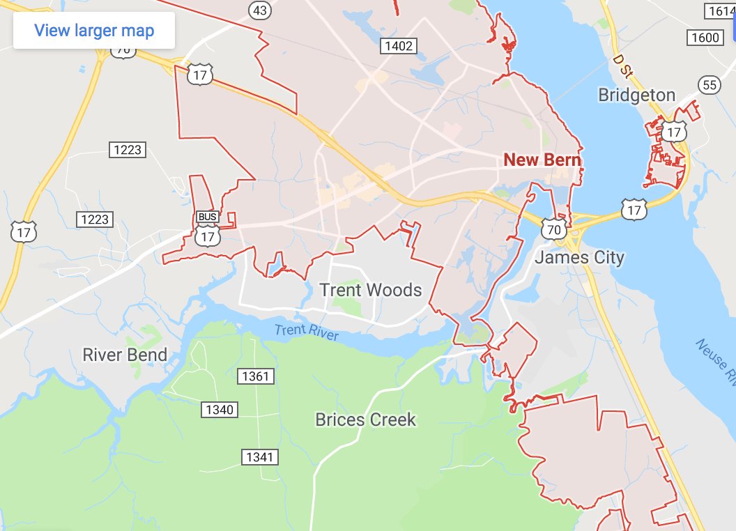
The church in New Bern where I spoke about the coastal threat posed by climate change a year ago (http://rothermelfoundation.org/october-22-2017-dr-michael-mann-on-the-hockey-stick-and-the-climate-wars/ …) has been flooded by Florence: https://www.newsobserver.com/news/local/article218323475.html … …

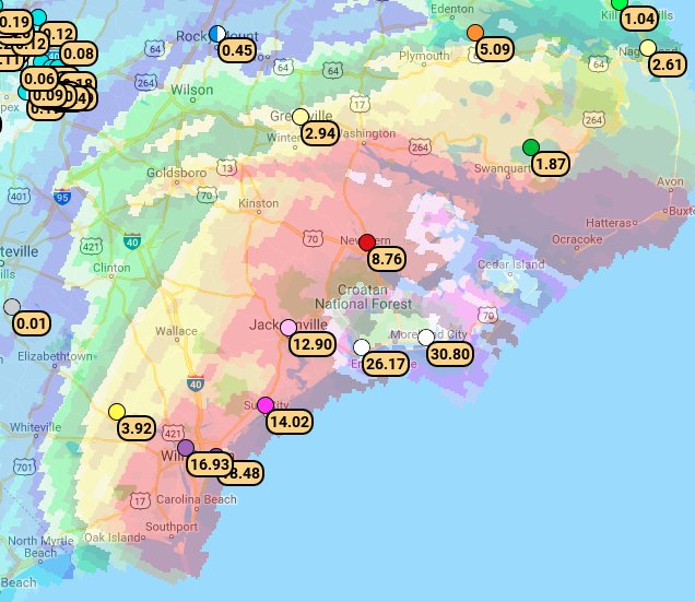
#Florence‘s 24-hour rainfall totals are obliterating state records, and it’s far from over.
http://bmcnoldy.blogspot.com/2018/09/florence-makes-landfall-but-life.html … @UMiamiRSMAS
(As usual, this will be a fluid post in which more information gets added during the day as it crosses my radar, crediting all who have put it on-line.)
I’m seeing a few major reports of “ETs” this evening for 9/14/18:

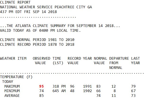
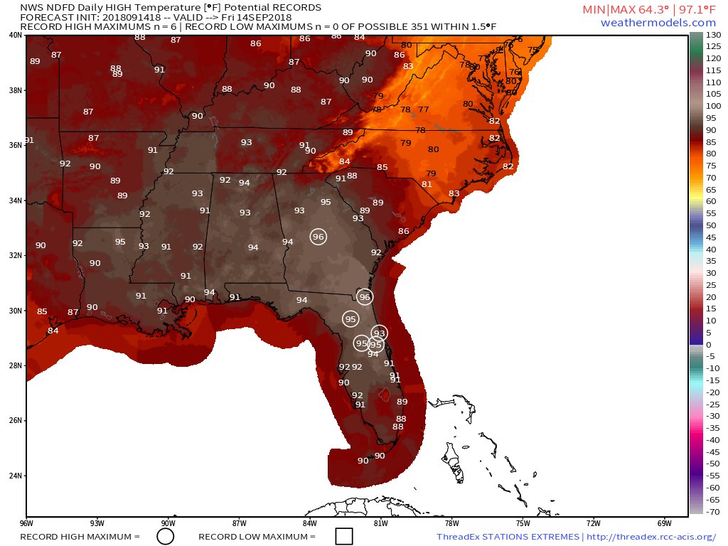
Two high temperature records set today. St. Simons Island tied the record of 95 degrees previously set in 1950. Gainesville also tied the record of 96 degrees, previously set in 1952. #flwx #gawx #climate

Anniston tied their record high of 96 today. Tuscaloosa hit 97 but fell short of the record of 100 set in 1980. Birmingham and Montgomery both hit 95.
(If you like these posts and my work please contribute via the PayPal widget, which has recently been added to this site. Thanks in advance for any support.)
The Climate Guy