Friday October 19th… Dear Diary. The main purpose of this ongoing post will be to track United States extreme or record temperatures related to climate change. Any reports I see of ETs will be listed below the main topic of the day. I’ll refer to extreme or record temperatures as ETs (not extraterrestrials)😊.
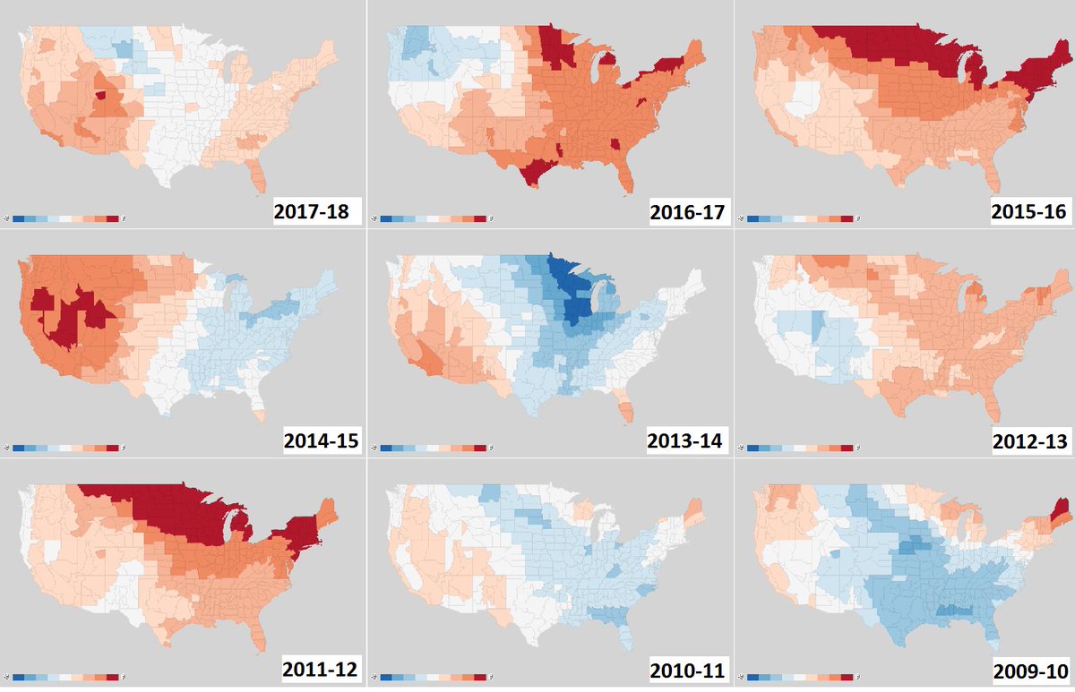
Highly Variable U.S. 2010s Winters
For about the last week The Weather Channel and other outlets have been disseminating forecasts about the coming winter after the National Environmental Climate Center issued their own. Personally I won’t do this until late November just before the boreal winter season begins on December 1st so I can get a better picture after I peer into my crystal ball 😉.
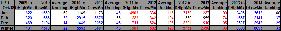
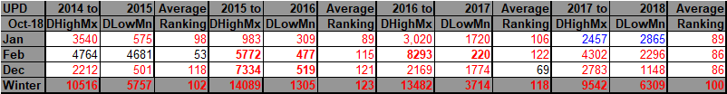
In any case I thought that today we would have a little fun looking at some record statistics I have compiled for the winter season for this decade, which also might serve for educational purposes. Due to global warming all of these winters have been mild, right? Wrong. We have seen highly variable winter seasons across the CONUS:

Here’s a look at the past 9 winters (Dec-Jan-Feb) and their temperature departures from average.
2013-14 sticks out as the cold one…the year ‘polar vortex’ came into pop culture:
What you need to know about our 2018-19 #WinterOutlook.
(Video with captions: https://t.co/07Kwu4wTcs) pic.twitter.com/OKFB49b7BP
— National Weather Service (@NWS) October 18, 2018
Why is this important? Because extreme cold can be just as much of a killer as extreme heat. At least global warming has brought about some relief in this regard. Also, the West depends upon some extreme cold to kill or lower populations of pine beetles. This is now a big climate change negative factor for forests. Ski operators and winter resort owners look at winter forecasts to make decisions on staffing, depending on a good snow pack, which won’t melt due to mild temperatures. Also, utility companies need to know how much heating oil and natural gas to store for customers (although I contend that in the future all electric heating should be essential to keep the climate healthy).
Another point. Seasonal predictions may be yet more unreliable due to big changes in the Arctic interacting with the jet. The dipole is one example.
Of course, I’ll keep all informed about any extreme temperature conditions as the winter begins, but first we need to get through November:

That’s a nice look for a storm late next weekend. Energy from the N & S branches of the jet track across the US w/ a potential phase for a nor’easter. It has to come together just right but the pattern is there. Too early to discuss p-type, but inland snow potential if it forms.
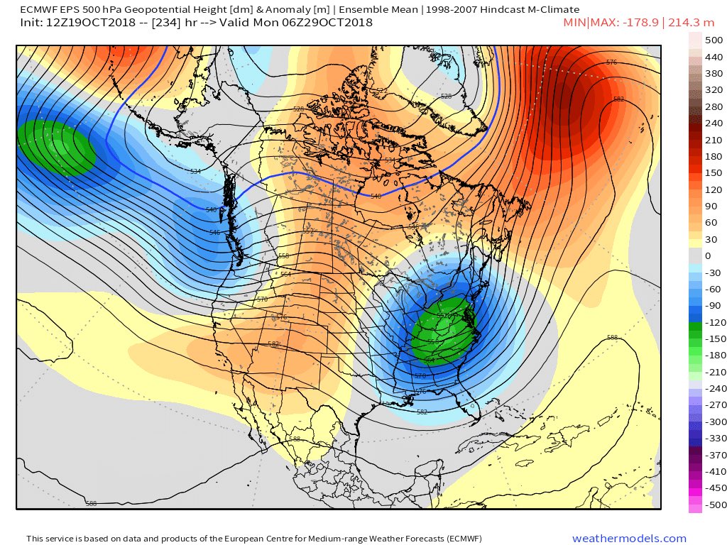

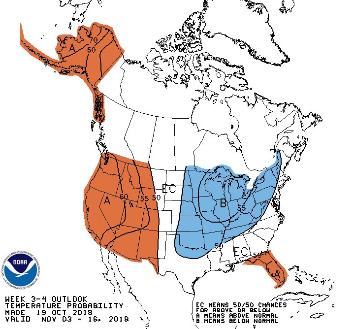
Todays Weeks 3-4 outlook for 11/3-16 draws strongly on high-latitude blocking expectations, leading to increased odds of above-normal temperatures for the West and below-normal temperatures from the Plains through Great Lakes. http://www.cpc.ncep.noaa.gov/products/predictions/WK34/ …
In conclusion, I suspect that the dipole pattern in association with the polar vortex interacting with a strong EL Nino from 2015-2016 have been big players for making winters highly variable this decade.
……………………………………………………………………………………………………..
(As usual, this will be a fluid post in which more information gets added during the day as it crosses my radar, crediting all who have put it on-line. Items will be archived on this site for posterity.)
I’ll be adding climate and weather information to this post as the day progresses.

The shirt speaks for itself despite devastation like the other pictures convey. The people of #MexicoBeach, FL have a herculean task ahead of them. But you can’t find one person who isn’t up for it. @weatherchannel will continue to tell stories after #Michael. #MexicoBeachStrong

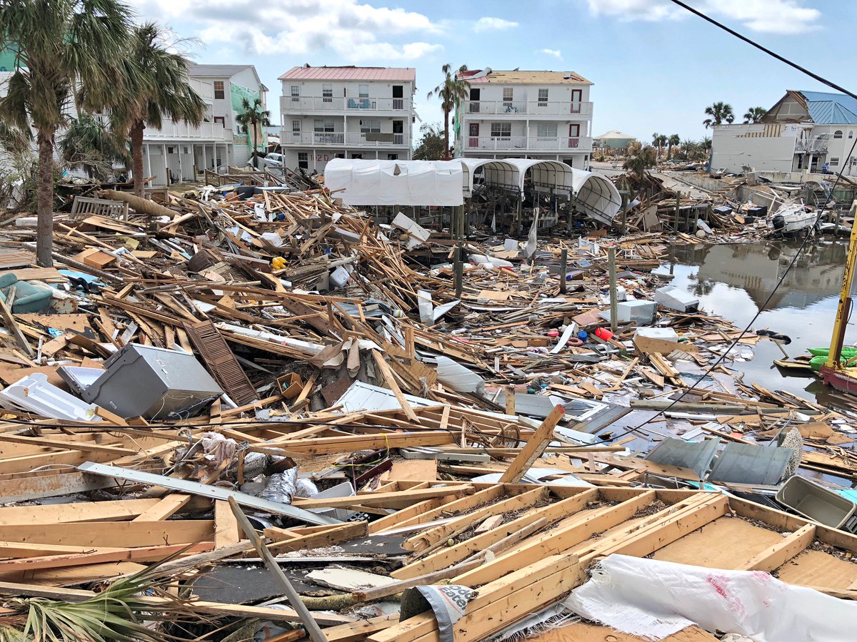
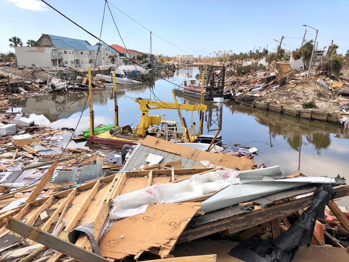
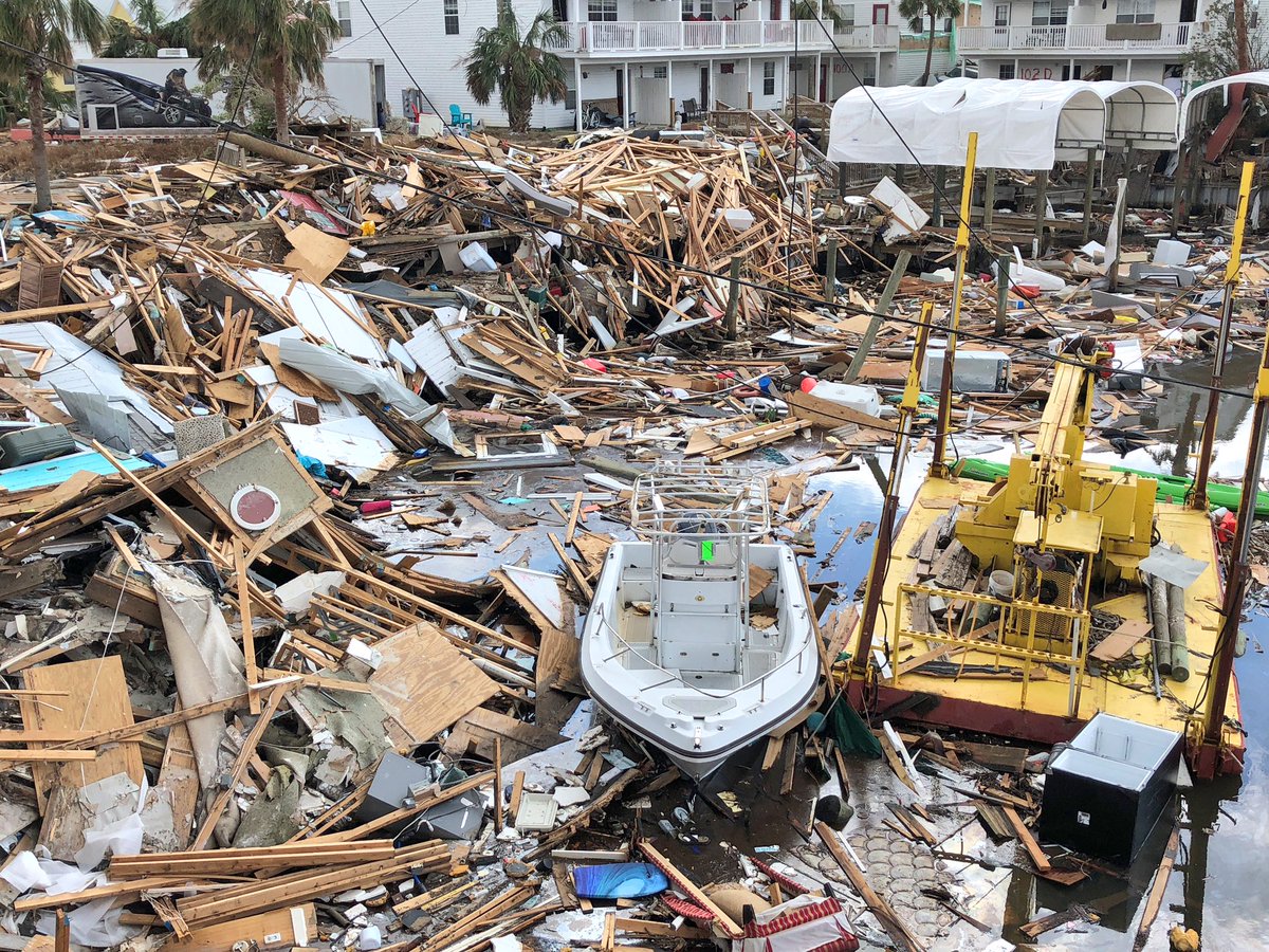

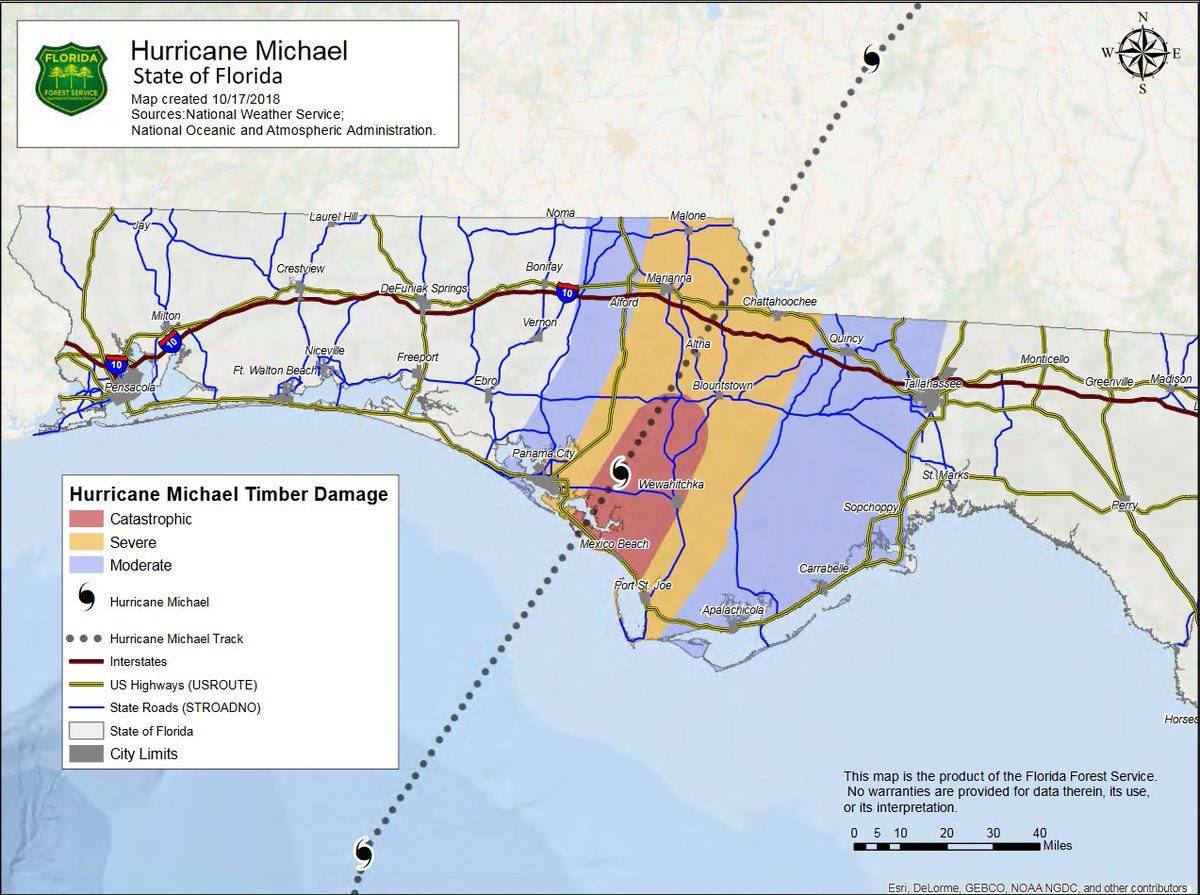
It can NOT be emphasized enough that hurricane #Michael was an inland wind disaster as well. It will take many years forests and crops to recover. #flwx #gawx

With Hurricanes and Toxic Algae, Florida Candidates Can’t Ignore the Environment | InsideClimate News:
2:33 PM – 19 Oct 2018

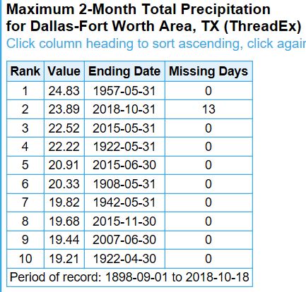
Another #DFW rainfall record about to fall. Wettest consecutive months. Current record? 24.83″ in April/May 1957. With 0.87″ so far today thru 4pm, current amount for Sept/Oct? 24.76″. Should fall in the next hour. #txwx
(If you like these posts and my work please contribute via the PayPal widget, which has recently been added to this site. Thanks in advance for any support.)
The Climate Guy