Monday October 15th… Dear Diary. The main purpose of this ongoing post will be to track United States extreme or record temperatures related to climate change. Any reports I see of ETs will be listed below the main topic of the day. I’ll refer to extreme or record temperatures as ETs (not extraterrestrials)😊. Here is today’s main climate change related topic:
U.S. October Cold Shots
I need to remind all that the Extreme Temperature Diary also takes into account any cold outbreaks as well as heat. Yes, even with increasing global average temperatures due to carbon pollution, the jet stream can still get oriented such that record cold air can occur over areas as large as a continent. We haven’t seen a weather pattern this relatively cold since April 2018 for most of North America and specifically the United States looking at my Record Scoreboard:

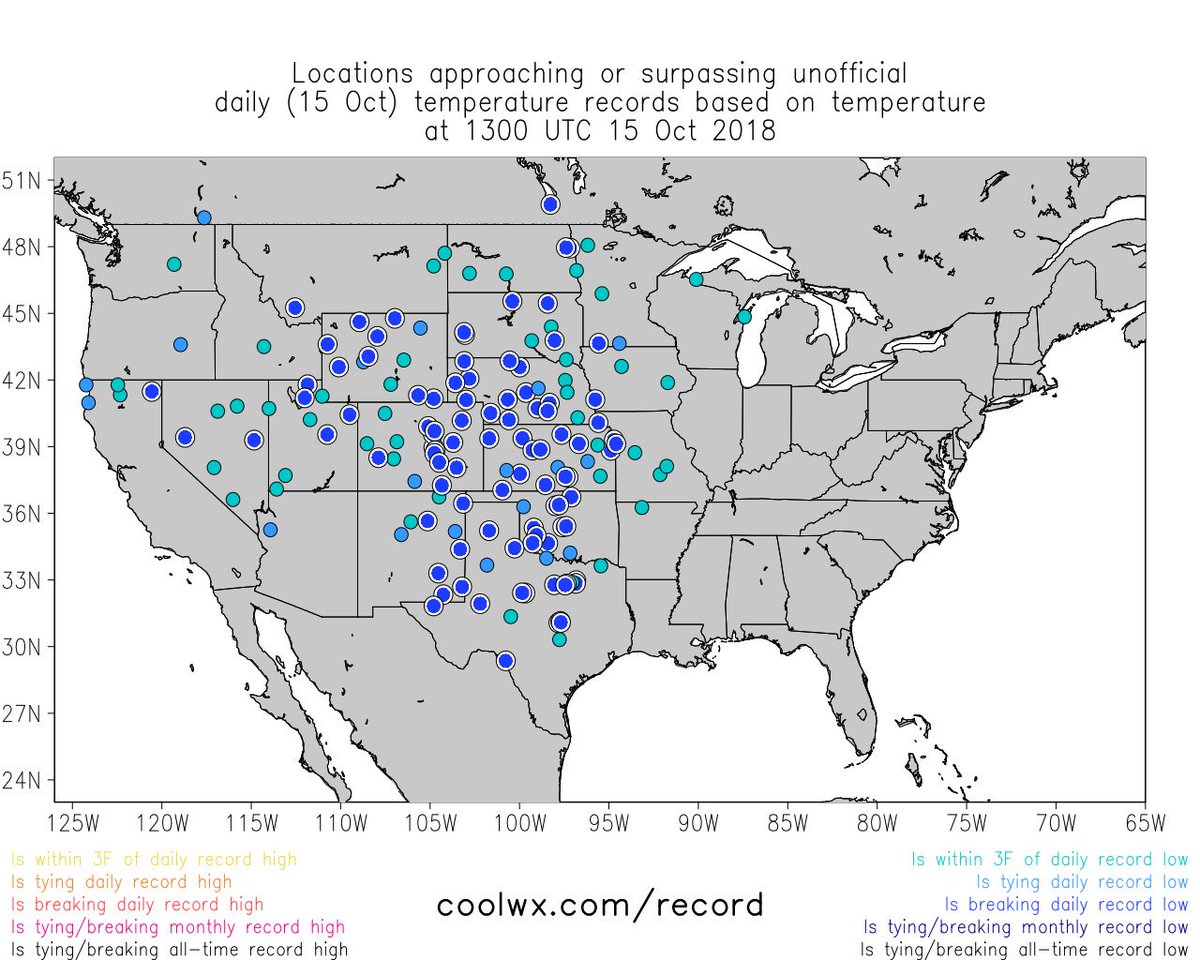
I’m estimating that about 500-1000 daily record lows will get reported for October 2018 from the cold shot that spread from Montana to Texas over the weekend:
About one third of the CONUS experiencing daily record low temperatures this morning!

 Bob HensonVerified account @bhensonweather
Not only did DFW set a record low of 41°F today, but the midnight high of 49°F makes today the earliest day on record—by a full week—where DFW won’t touch 50°F. Old record is Oct. 22, 1936 (when high was just 48°F).


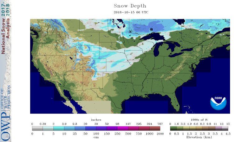
A “November” like front put down a fairly thick layer of snow from the Rockies into the Plains. Sunday at midday we had at 1034 millibar high centered over Wyoming. The higher the pressure moving southward from Canada usually the colder the air mass during fall and winter. This area of high pressure was also responsible for producing strong Santa Ana winds this morning in California as it built into the Great Basin. Here is one of the end results:
We officially gusted to winds of 73 MPH this morning. You’re favorite tree-hugger is a bit sad to see his tree outside his winder suffer.
Still, it is the cycle of life, and the tree will live.

It’s typical to see snow in the Rockies in October but not at lower elevations going eastward to the Great Lakes as occurred from Saturday into Sunday:
SNOW: rain changes to #snow along I-135 corridor north of Wichita, KS with a winter weather advisory in effect until 2 am for up to a few inches of accumulation. Roads are slippery tonight across central/northern KS. Live from Salina in the morning on @accuweather #kswx pic.twitter.com/lV7RuggGJh
— Reed Timmer, PhD (@ReedTimmerUSA) October 15, 2018
Interesting #snow oddity: Kansas City and Wichita both saw their first accumulating snow before Fairbanks, Alaska. Fairbanks’ average first measurable snow is Sept. 27.
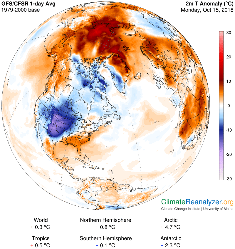
Over the weekend we did see record heat in Scandinavia.
The first cold shot will be petering out over the Plains tomorrow but will produce the first freeze of the fall season for many in the Midwest:

I do expect a few more reports of record lows from the Plains on Tuesday looking at this forecast:
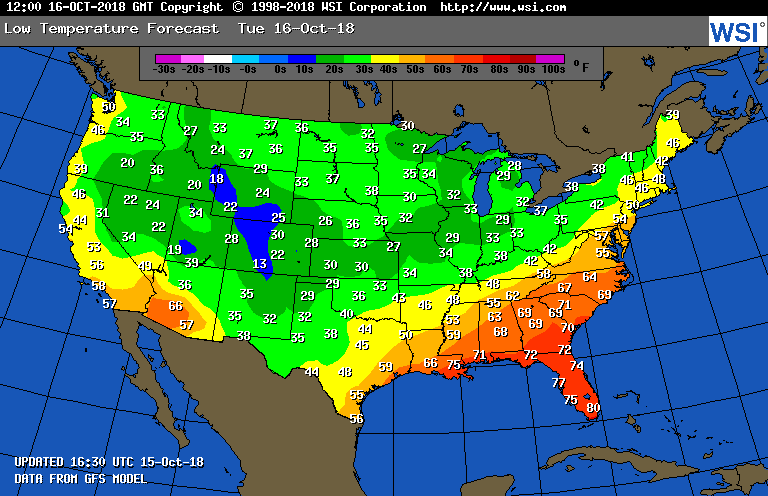
Twenties and thirties will be quite common for minimums from Texas northeast through the Great Lakes.
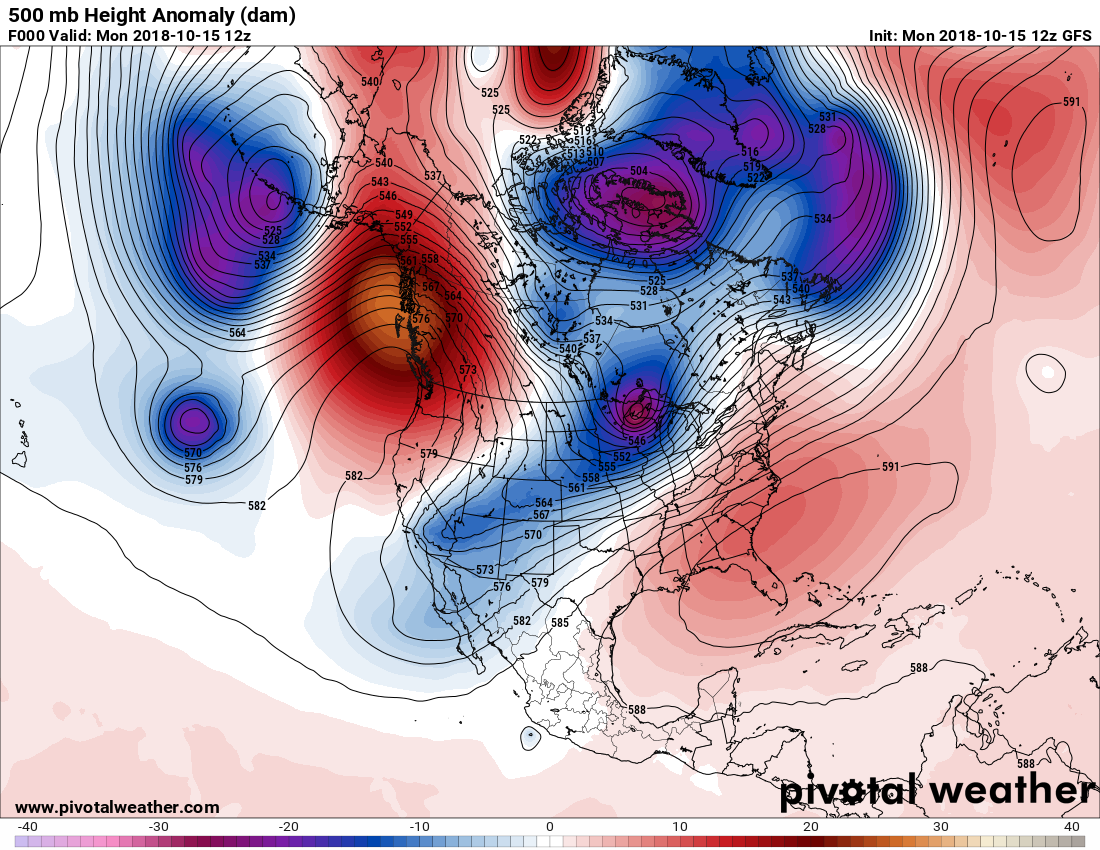
We are due to see a reverse in the pattern later this month sending shots of near record cold air into the East. The first comes this week on Wednesday through the Great Lakes as the Greenland vortex consolidates:

A deeper, colder through will be digging into the East over the weekend:
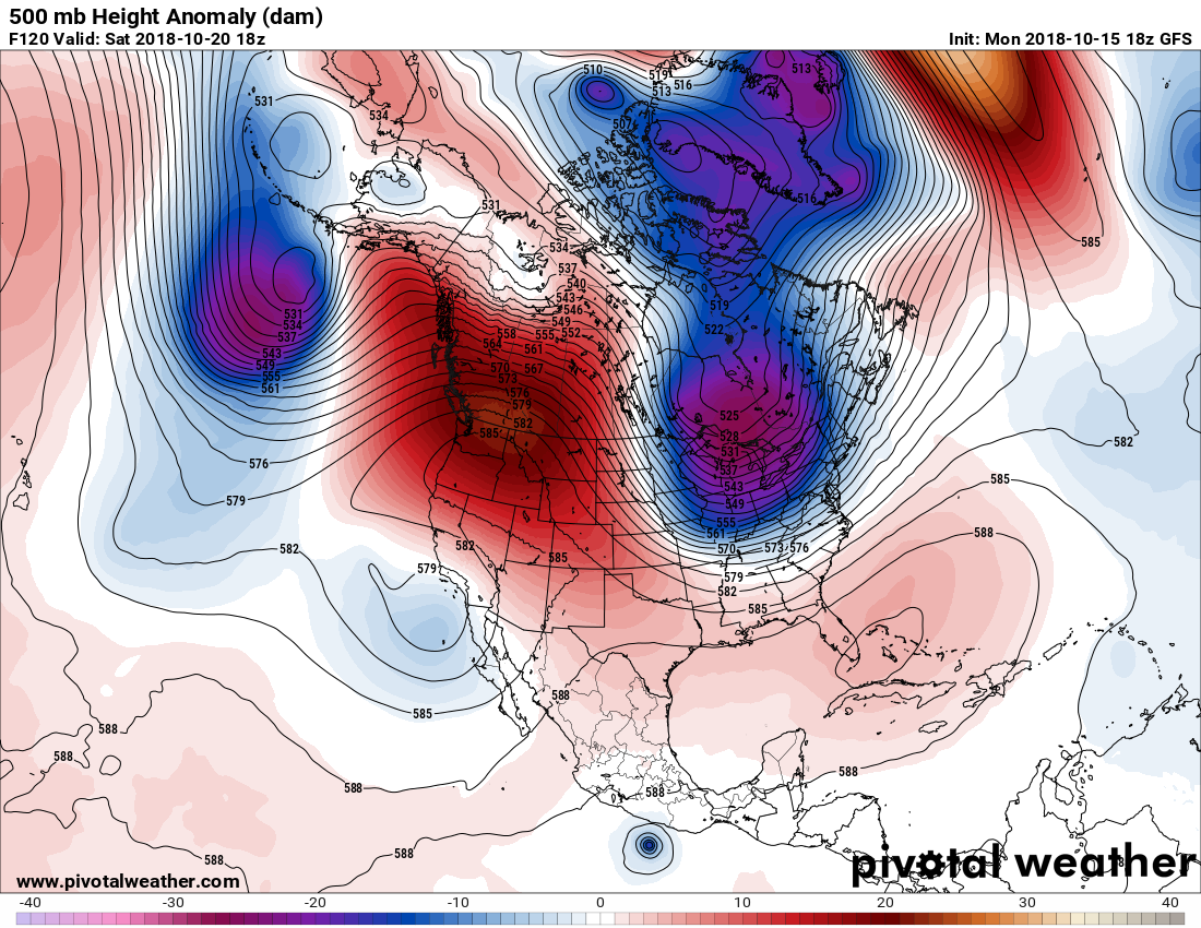
The corresponding ridge over the Pacific Northwest that has 500 millibar heights at near record high levels will produce some record warmth through the weekend such as this:
Record high temperatures could be set or broken Tuesday at #SeaTac AP (forecast high of 69°; record 70° in 2002 & 1974) & #Quillayute (forecast high of 70°; record 70° in 1972). On Wednesday, #Hoquiam could do it as well (forecast high of 72°; record 73° in 1989). #WAwx
The polar jet has a clear shot from the Arctic all the way south to the Southeast. I’m impressed with the associated polar airmass moving south through the weekend by mid October standards:
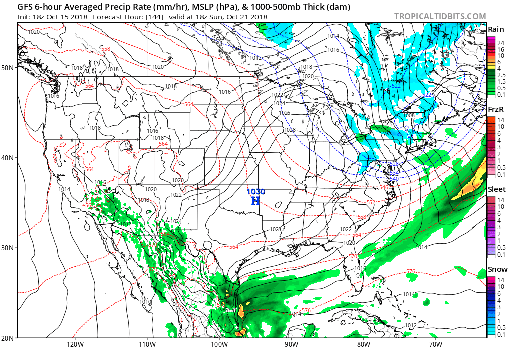
We will see the lake effect snow machine turn on across the Great Lakes. That 1030 millibar high may score some record lows from the Plains into the South. On the flip side of things it may get warm enough to see record heat in the Pacific Northwest.
Will this be the pattern for the winter? It’s too early to tell, especially with an El Nino looming in the works. Will climate change deniers jump on this cold pattern to press their points? That’s a definite you bet.
………………………………………………………………………………………………………………………
Here is some of today’s climate and weather news:
(As usual, this will be a fluid post in which more information gets added during the day as it crosses my radar, crediting all who have put it on-line. Items will be archived on this site for posterity.)
If you live along the coast and are ever on the fence about whether or not your should leave when a Hurricane is threatening…just replay this women's answer. Interview by @JMichaelsNews pic.twitter.com/HJwtjfUmhh
— Alex Wallace (@TWCAlexWallace) October 15, 2018
The NOAA-20 polar orbiting satellite captured this image earlier today of the remnants of former Hurricane Leslie over the Iberian Peninsula merging with a north-south oriented cold front over western France, while the remnants of former Hurricane Michael approach Spain.

“All of the Big Three automakers—GM, Ford and Fiat Chrysler—have shifted toward big, heavy vehicles that drink more fuel per mile.”
“President Trump Just Questioned Human-Made Climate Change In A TV Interview. Scientists Are Disturbed And Disappointed” by Zahra Hirji (@Zhirji28) for The @TheDailyBeast:
https://www.buzzfeednews.com/article/zahrahirji/trump-denies-climate-change-60-minutes
6:06 PM – 15 Oct 2018
Full September 2018 U.S. Climate Report now available: http://www.ncdc.noaa.gov/sotc/national/201809 … #StateOfClimate

Here are some of those not so world famous “ET” reports:
El Paso’s high temperature today was only 54 degrees, which occurred at midnight LST. That is 25 degrees below normal for this time of year. It also broke the record for the coldest maximum temp to occur on this day, 10/15. The previous record was 61 degrees set in 1970. #txwx

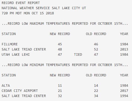
Here’s a list of record cold temperatures across Utah today: #utwx
(If you like these posts and my work please contribute via the PayPal widget, which has recently been added to this site. Thanks in advance for any support.)
The Climate Guy


